Introduction:
To the north east of the former medieval walled town district town ly the historical streets of Cork such as Cornmarket Street, Paul Street and Emmet Place. This district developed from the early seventeenth century onwards. It once hosted the “Walkabout” fortification to eventually becoming the centre of trade in the early eighteenth century with the primary custom house being located there.
Soon streets and formal quaysides were constructed upon the marshland – much of such development was instigated by Huguenot merchants. Part of their graveyard can still be viewed on Carey’s Lane. Add in beautiful church sites, a municipal art gallery and one gets a rich historical quarter of Cork City.
The brief historical walking trail covers some of the topics on my physical walking tours. The information is abstracted from various articles from my Our City, Our Town column in the Cork Independent, 1999-present day, Cork Independent Our City, Our Town Articles | Cork Heritage
The Watergate Complex:
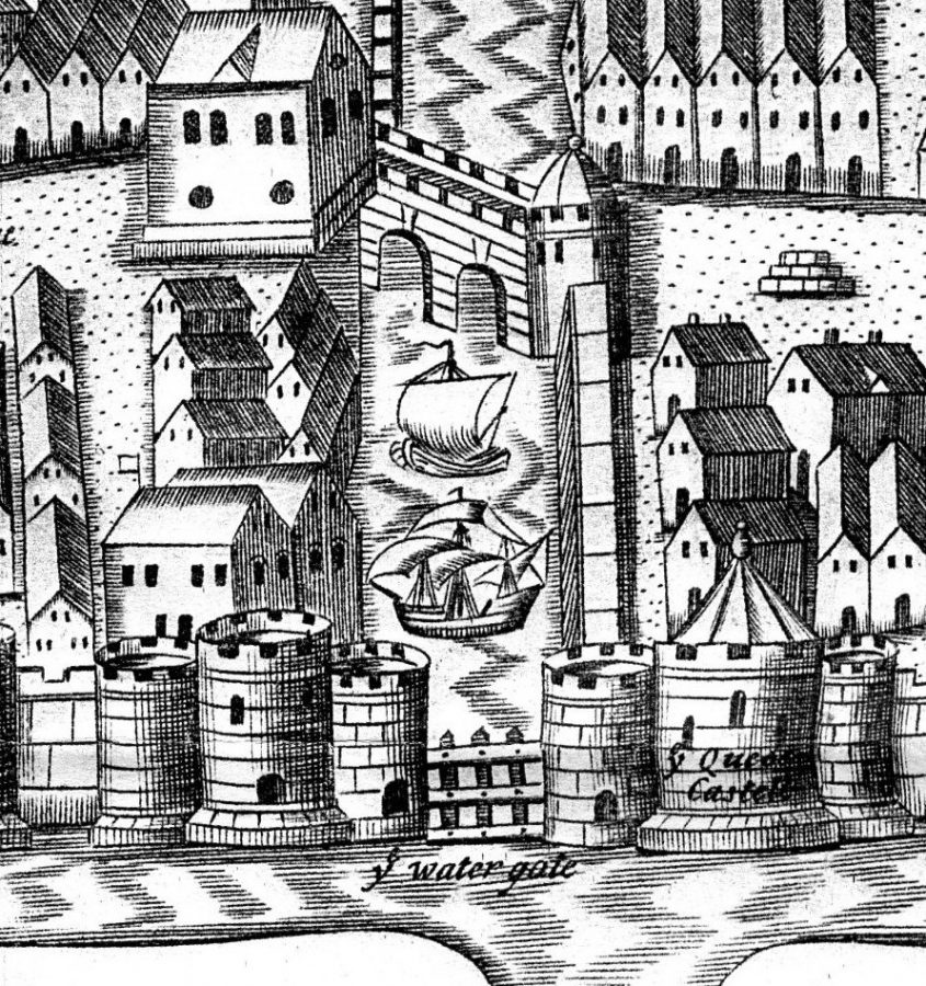
The ship entrance overlooked the eastern marshes and was located at the present-day intersection of Castle Street, Cork Market Street and the Grand Parade. Known as Watergate, it comprised a large portcullis gate that opened to allow ships into a small, unnamed quay located within the town.
On either side of this gate, two large mural towers, known as King’s Castle and Queen’s Castle, controlled its mechanics. Little evidence remains of the gate, but on the basis that it had to allow access by ships with full masts, Watergate possibly divided in two and opened like a door, rather than being wound up and down by means of a stout chain on a pulley system.
In 1996, when new sewage pipes were being laid on Castle Street, archaeologists found two portions of rubble that indicated the site of the rectangular foundations of Queen’s Castle. A further section was discovered in 1997. During these excavations, sections of the medieval quay wall were also recovered on Castle Street.
The Exterior Walkabout & The Eastern Marshes:
Cork in the first decades of the seventeenth century was valued as the third most important port after Dublin and Waterford. The growth in prosperity was mainly attributed to the increase in utilization of the surrounding pastoral hinterland surrounding the city Large sections of woods were cleared in Munster to accommodate the large demand for pasturalism. However, in 1610, a report by the commission of the Munster Plantation noted that the woods were being depleted too fast in order to clear land so sheep could graze on it.
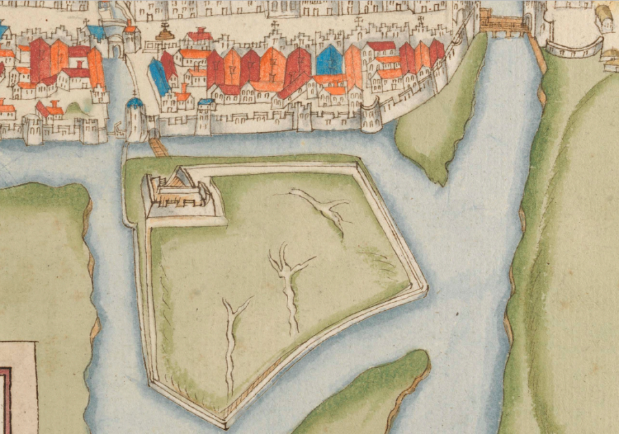
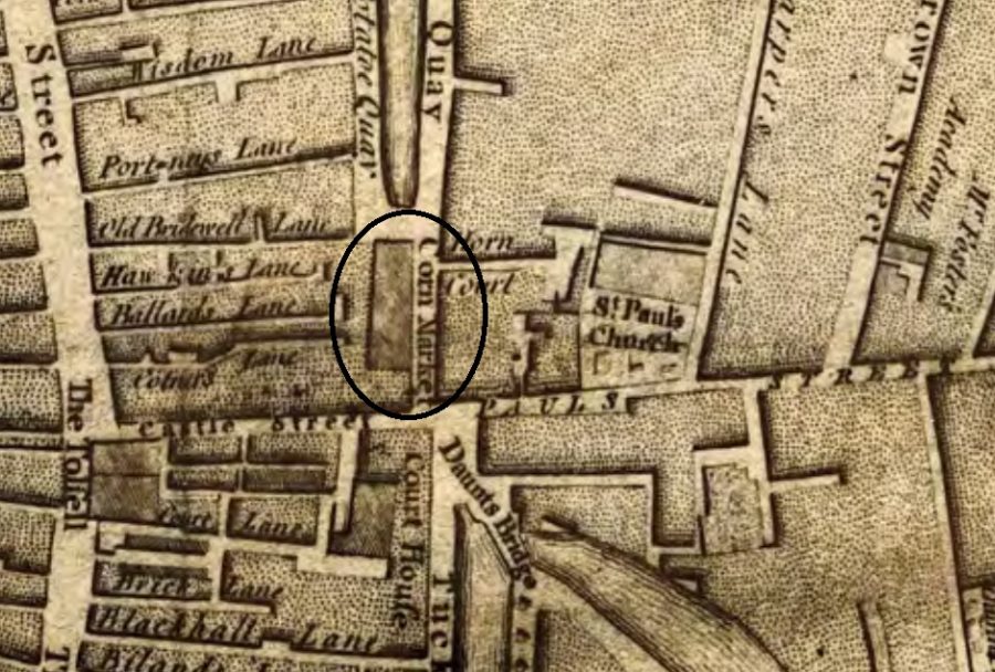
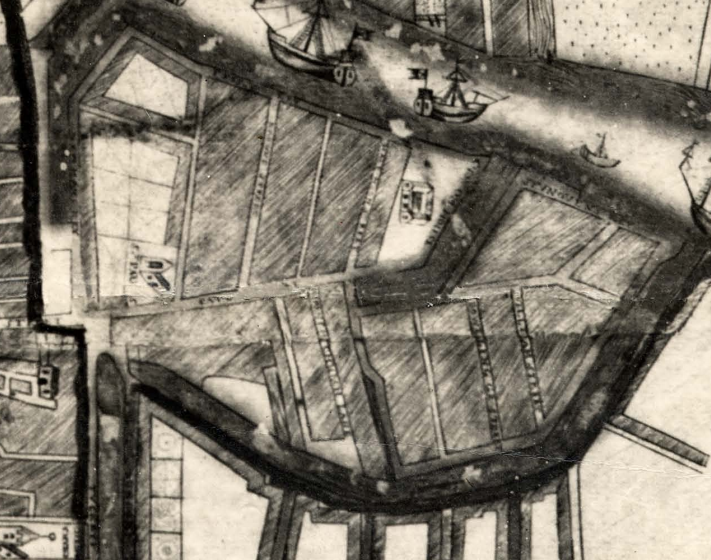
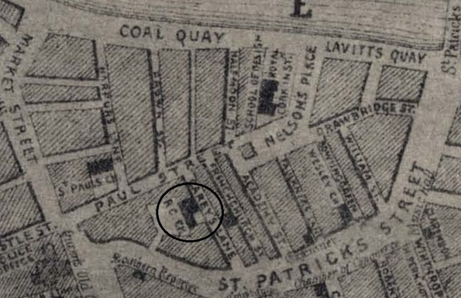
The increase in trade meant that a large new structure encompassing a dock and fortifications were constructed. It was constructed on the edges of one of the marshes to the east of the town. The dock, sometimes referred to by historians and archaeologists as the Walkabout, can be seen in George Carew’s depiction of the walled town of Cork c.1602. He shows a timber bridge extending to the edge of a marsh leading to a castellated building. From this building a wall walk is shown running on top on wall running around the edge of the island.
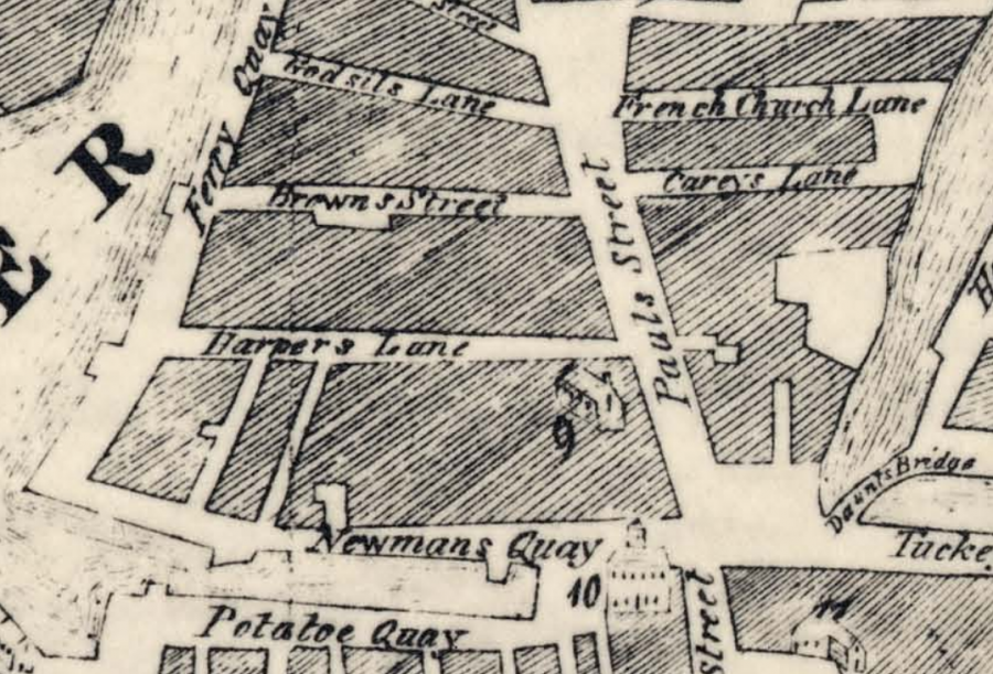
The structure would have extended from Daunt’s Square, down the northwest side of St Patrick’s Street as far as Academy Street, northwards as far as Lavitt’s Quay, westwards to Corn Market Street and then southwards to rejoin Daunt’s Square. By 1690, the town’s custom house was moved from the centre of the walled town to this new dock.
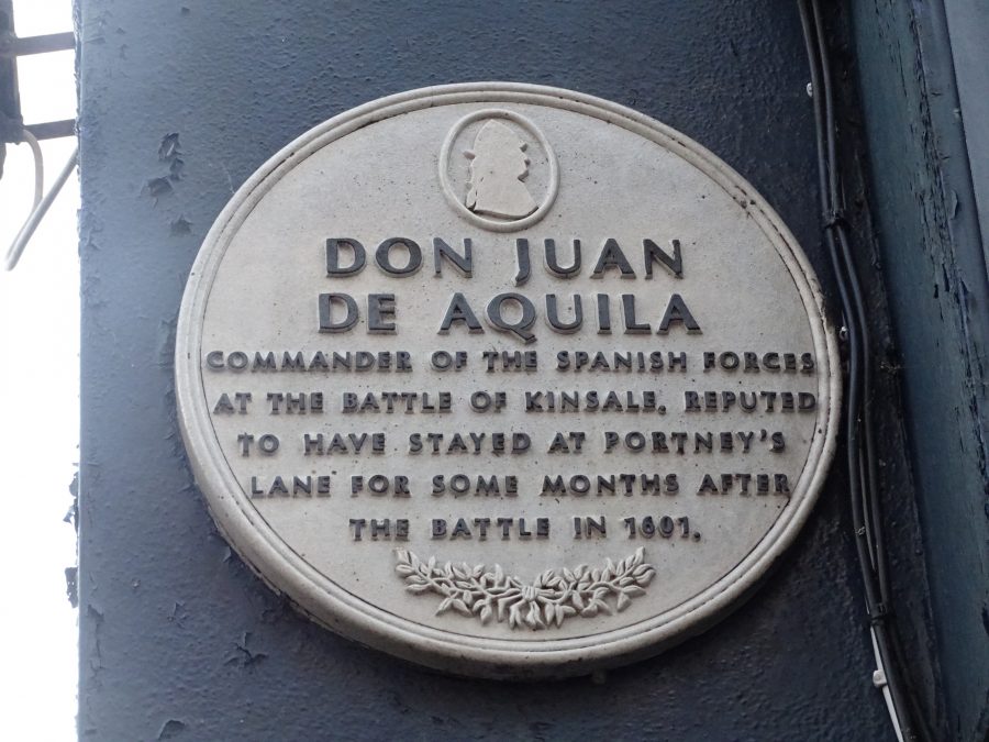
Don Juan Del Áquila and his Plaque:
On 23 September 1601, during a meeting of the Queen Council in Kilkenny, a message was received that a Spanish fleet had arrived off Kinsale Harbour and had taken the town and its environs. Approximately 3,500 Spanish soldiers had landed at Kinsale, 700 at Baltimore. The English responded by sending 2,000 men, under the leadership of Charles Blount, Lord Mountjoy, to join the 7,000 already stationed in Cork, and the town became a crucial pawn in the attack on the Spanish invaders.
The Spanish leader, Don Juan Del Áquila, sent word for help to O’Neil and O’Donnell. O’Neil immediately left his northern territories and marched south with 4,000 men and 200 horses. Arriving at Kinsale, O’Neil’s army surrounded the town, but were flanked by English despatches and forced to retreat. The English prepared for a lengthy siege of the Spaniards’ positions at Kinsale, Baltimore, Castlehaven and Berehaven. In January 1602, Don Juan Del Áquila agreed to evacuate his troops and the Spanish-Irish campaign came to an end.
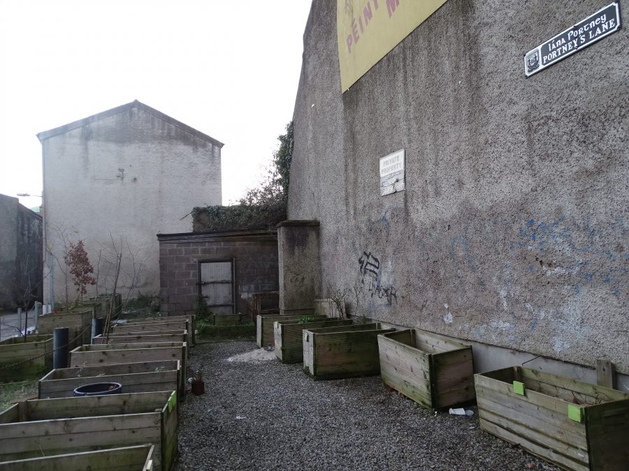
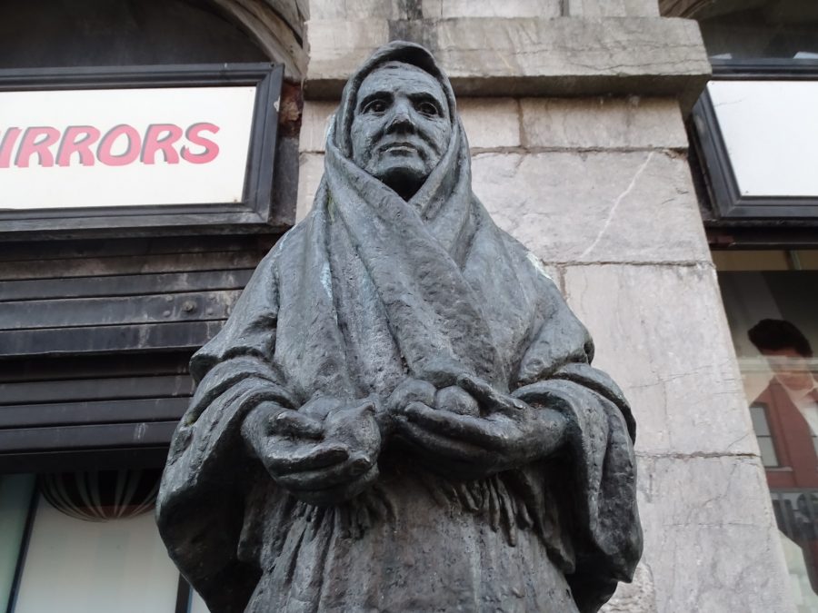
A plaque on Corn Market Street refers to Don Juan staying at Portney’s Lane for a while after the Battle of Kinsale.
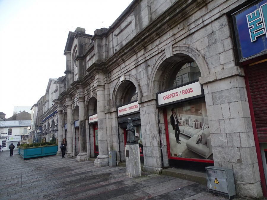
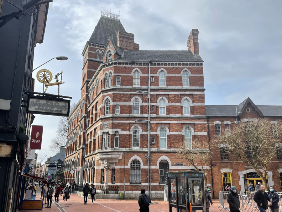
The Corn Market:
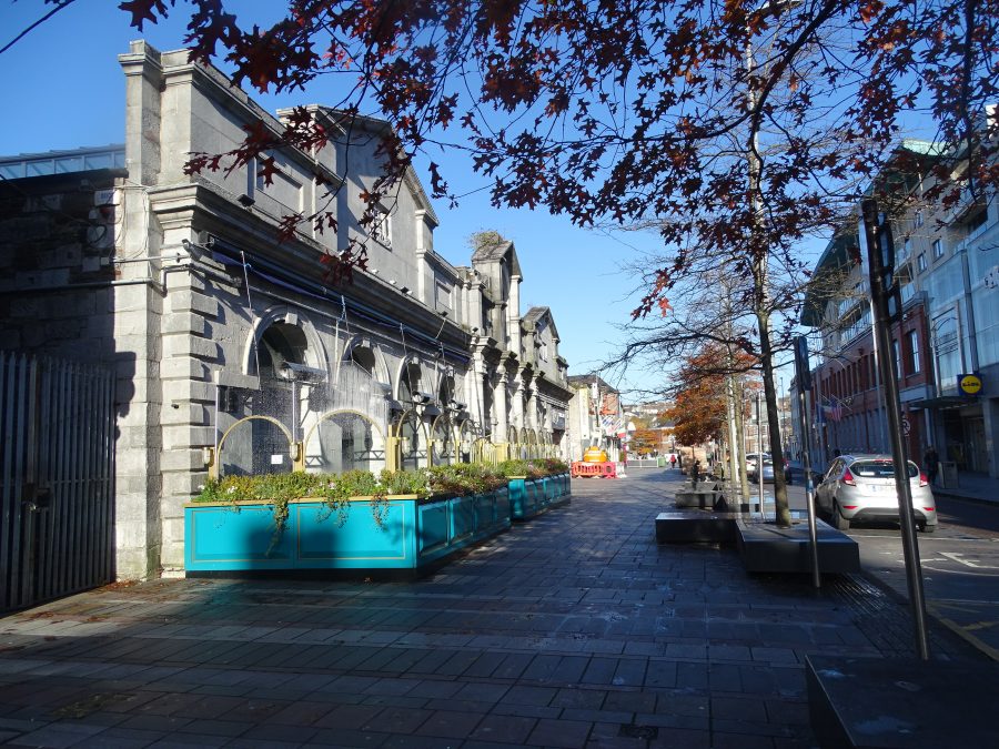
The first municipal corn market was constructed in 1719 overlooking a square that was located on filled-in portion of a channel (est.c.1695) of the River Lee. Unfortunately, the name of this square is not recorded, but it was located on what is now Corn Market Street.
Over the centuries, the square grew to be the traditional central market area of the city. It would have been thronged with dealers and customers, purchasing anything from a needle to an anchor. Several stalls still operate here today.
The second edition of the Cornmarket building still exists. Initially constructed in the 1740s, this building is reputed to be the work of Italian architect Allesandro Callileo. One hundred years later, the building was remodelled, and reopened in 1843 as a corporation bazaar. The quality of the masonry is a core characteristic in the streetscape and was expertly carried out by skilled stone cutters and masons.
Kathy Barry, Publican (1909-1982):
Kathy ran a small provisions shop (now demolished) in Dalton’s Avenue, off the Coal Quay. She was synonymous with the Coal Quay. She was famous for her crubeens, which were always in great demand once the local pubs had closed. There was also a chance of a few glasses for special customers. She lived in later years across the road at no.6 Corporation buildings. She died at the Mercy Hospital, Cork on 17 December 1982 and was buried in St Joseph’s Cemetery, Cork.
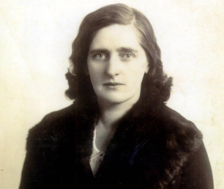
WATCH a short film by Kieran on the commemoration of Kathy Barry’s life and times at St Joseph’s Cemetery, Cork. 27 December 2019
Promoting Corn Market Street:
During 2011-2012, over €1 million has been allocated by Cork City Council with the help of European Structural Funds for the refurbishment of Cornmarket Street. The street underwent a massive facelift to give it the feel of a European outdoor market. Stalls were replaced by modern ones. Conscious of the effects of change on tradition an annual festival has been organised by the Cork Middle Parish and the Coal Quay Historical Society from 2012 onwards.
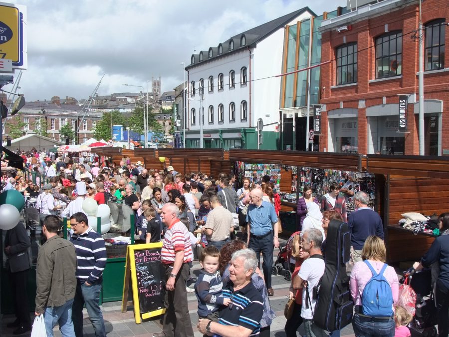
WATCH a short promotional film by Richard T Cooke on the Coal Quay Festival, 2013
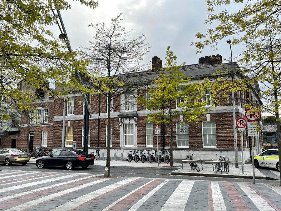
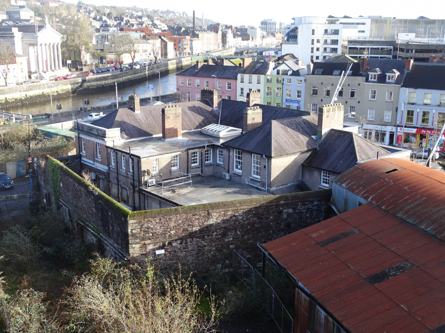
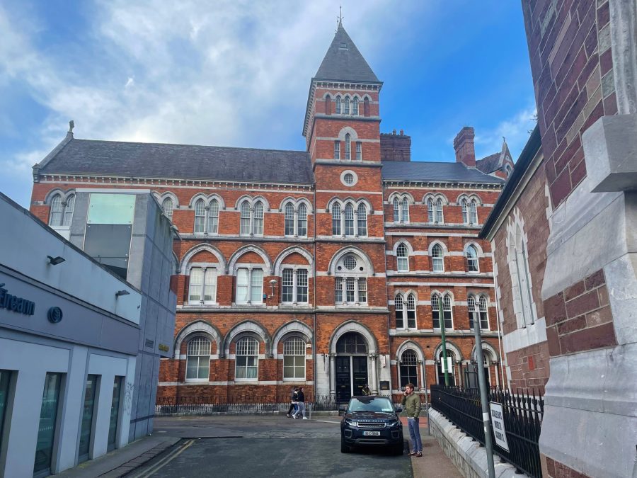
The Historic Bridewell:
Until the early eighteenth century, the Bridewell was located further south towards Castle Street at the marked Old Bridewell Lane.
The new Bridewell, built c.1731, was the first building to stand on the Cornmarket Street site, which had previously been marshland outside the city wall.
In 1922 the eighteenth century building was extensively burned. The extant ruins were demolished in 1924. Work began in 1931 on the ‘first custom-built Garda Station’ of the Irish Free State Government. The contractor was J Healy of Pine Street, Cork whilst the architect was Joseph Parnell Martin, who worked for the Office of Public Works.
The Evening Echo for 22 April 1933 writes of the new building ready for occupation:
“The new Bridewell building, which has been erected on the site of the old one, destroyed during the Civil War period, is now neared completion, and, it is believed, will be taken over by the Civic Guard authorities some time next week. The new structure is situated at the junction of Cornmarket Street and Kyrl’s street, the main entrance being in the latter thoroughfare. It presents an attractive appearance, the outer walls being constructed of coloured brick and white cut stone. The interior is no less attractive, the walls being smoothly cemented, and the floors covered with rubber matting of a pleasing design.
The touchstone of the design has been one of comfort and solidarity in the construction of the new Bridewell. Accommodation is provided for about thirty men. Hot and cold water is provided in all the washrooms, and the building is electrically lighted throughout. The area of the enclosed yard at the rere is approximately 60 square feet. Here a garage and workshop is situated, with a separate entrance leading out on to Kyrl’s street There are also some store-rooms and bicycle sheds, with accommodation for 36 machines”.
The building was formally handed over to the Garda Síochána on 12 June 1933.
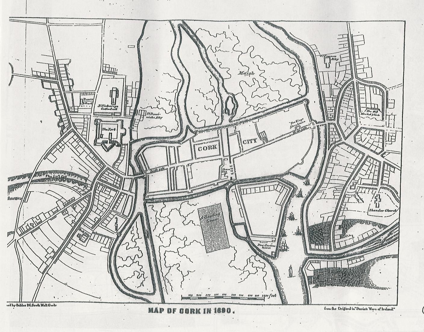
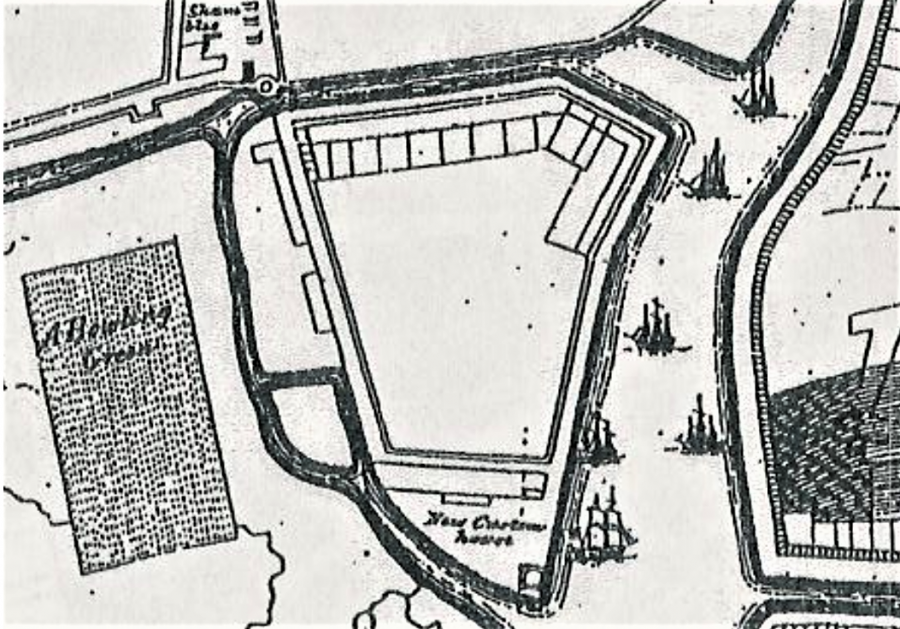
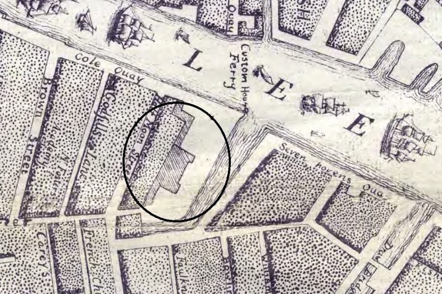
Storey’s Map of Cork, 1690:
Outside the walled town settlement, the most significant development shown was the exterior ‘Walkabout’ on the (north) eastern marsh. Originally constructed in the opening years of the 1600s, it can be argued from initial depictions that it was extended by 1690. The plan depicts a “new custom house” at the tip of the marshy island. To the west of the map or closer to the walled town, property plots are laid out within the island.
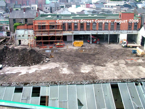
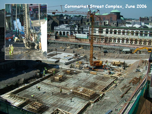
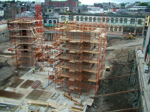
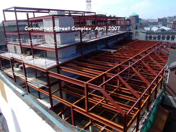
TK Max and its Archaeology:
To prepare for the T K Max complex archaeological excavations were carried out in in 2005 by Sheila Lane and Associates. The archaeology company lodged their report with Excavations.ie. The report shines a light on the reclamation methods in the early eighteenth century especially to the west of the north east island.
READ: 13228 « Excavations
In summary the report records that seven areas (2500m2) were excavated and these totalled almost the entire area of the development site.
Areas 1 and 5 were excavated along the western perimeter of the site and the remaining Areas 2, 3, 4a, 4b and 4c were excavated to the east of these.
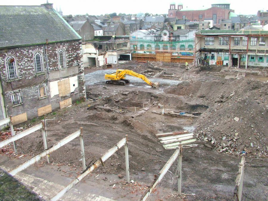
Excavation confirmed that extensive reclamation of the marsh to the north east of the town took place in the post-medieval period.
- Accumulations up to 1.7m thick of degraded domestic waste were discarded onto the estuarine muds all along the complete western and southern edges of the site. The waste comprised sizable quantities of post-medieval pottery, clay pipes and animal bone.
- The lower slopes of these organic deposits had been spread to the north and east to create a broad arc throughout the development site. These were covered by a deposit of manually introduced estuarine muds, which closed both the deposits and the wet muds to the north-east.
- The report notes that reclamation was sustained by dumping local gravels, crushed stone and locally dredged mixed riverine clays and gravels into this sealed, bowl-shaped area.
The earliest structures erected on the reclaimed marsh were located in the south-west of the site c. 15–20m east of the existing Cornmarket Street front.
Excavations.ie Report records:
“The construction of the houses may dates to the late seventeenth century. House 1 (Areas 1, 4a) had an internal east–west length of 8.2m and was built upon a “lime-mortared offset foundation of sandstone”.
“A formally laid out garden to the rear of House 1 is contemporary with the building. An area of flower or herb beds, edged with the metapodial bones of cattle was defined by a path of green sand (also edged with cattle bone) to the west and a path of horizontally laid cattle bones to the north”.
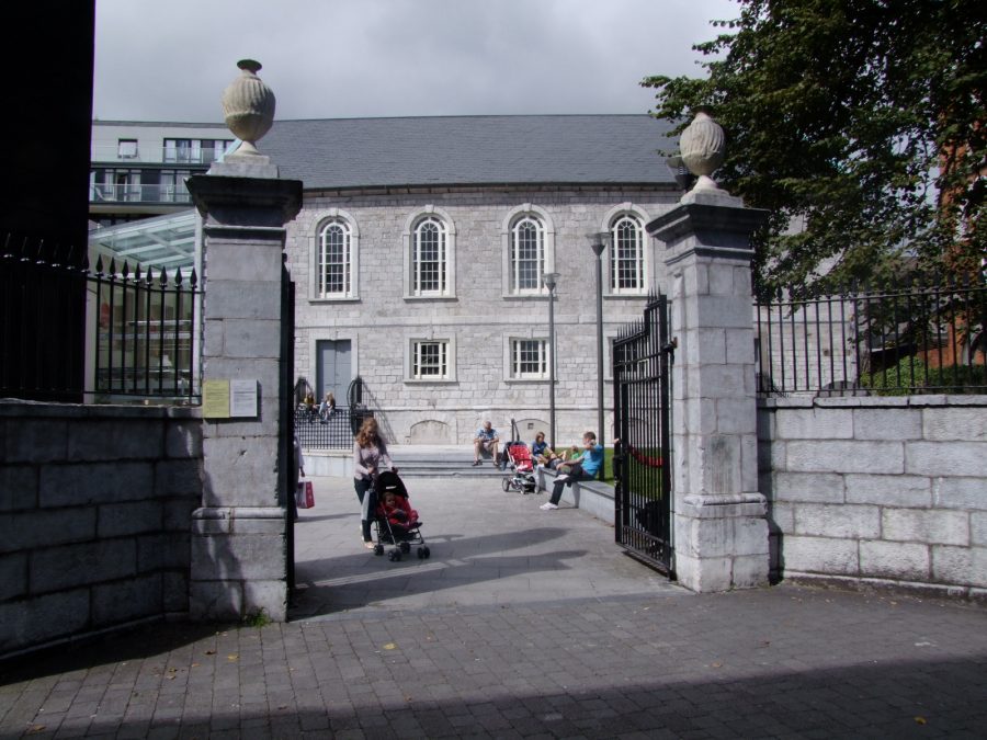
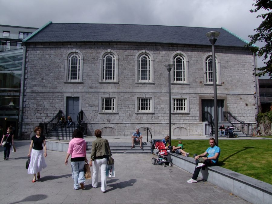
St Paul’s Church – A Sailor’s Resting Place:
All eighteenth-century maps of the north east marsh shows St Paul’s Church as a prominent building and a catalyst for further construction in the area and streets such as Paul Street.
Construction of St Paul’s Church began on 11 May 1723. It was built by subscription of £1,897 by parishioners and land granted by the Corporation of Cork to Peter Brown, the Protestant Bishop of Cork, from 1709 to 1735. The Corporation also voted £300 towards the project, and the church was finished with the aid of the tax levied on coal and culm by Act of Parliament.
The stucco work on the interior is worthy of notice. It is said to be the work of Italian prisoners taken during the Napoleonic Wars.This was a time of great expansion by the Church of Ireland and St Anne’s Church, Shandon was built the year before. The first service in St Paul’s was held by the Rev. Edward Sampson on October 9, 1726. By 1781, the parish of St Paul’s had both a rector and a curate.
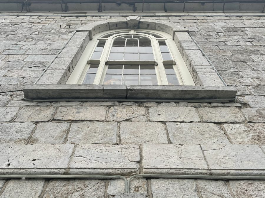
The church took six years to complete and was built on an island surrounded by marsh and water beyond the old town walls. It is an oblong building, without tower or spire. The building is Grecian in style with a very beautiful interior capable of accommodating more than 600 people.
Shortly after the initial building of the church was completed, the clergy decided to delineate a parish for the new church, which would offer a maintenance for Rev Sampson.
A further document by Cork Corporation to the parishioners, dated 1 September 1737 ordered a “draft of deed be prepared by the parishioners of St Paul’s Church for the grant to the Mayor and Constables and their successors as trustees of the ground before said church for a burial place for strangers and others who die in the parish, such as the mayor and Corporation shall recommend as object of charity to be buried without fees”. In other words, a pauper’s graveyard was created. This led to a large number of seafaring men being interred in the churchyard – the area being the centre of local shipping. Underground crypts were the resting places of a more gentrified citizenship.
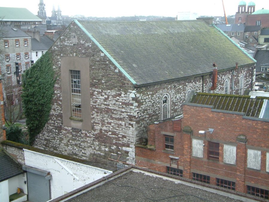
Like many Protestant churches in the city, St Paul’s thrived for 200 years but, like the community, it began to wither in the latter half of the twentieth century. The church was de-consecrated in 1950 when Guy’s Printers took it over and it fell into ruin when the company left in 1997. It is also generally believed that some table tombs were removed and or demolished.
The church is now the retail premises of Fifty Degrees North as part of the TK Max retail complex with its unexcavated underground crypt and Italinate ceiling, beautiful remaining features.
St Paul’s Graveyard:
The western side of St Paul’s Graveyard was levelled and in the late 1960’s and early 1970’s headstones were re-deposited on the eastern side of the graveyard. Some limited ground works for the new paving and signage in the former graveyard as part of the current retail development were undertaken in June and July 2008. The need for minimum disturbance of the archaeological remains present on the site dictated the work permitted.
Archaeologists Sheila Lane and Associates in their report on Excavations.ie revealed that the soils removed comprised a “large amount of disarticulated human remains, brick and stone rubble, and some coffin furniture”.
Other finds including:
“Deposits of stony rubble, built up against the south face of the church to raise ground levels, contained a number of headstone fragments likely to have been debris from the ground reduction of the churchyard in the past”.
“Three grave slabs were noted within the soils. All remain in situ beneath the landscaped churchyard”.
“Four subsurface vaulted brick tombs were noted during monitoring. Two were faced with stone. Three of these brick vaults extended south in a line against the eastern boundary wall of the graveyard from the face of the church. The fourth vault was located to the south of the western doorway to the church and had a splayed stone entranceway with a cast iron gate”.
READ more at: 19223 « Excavations
Carey’s Lane Chapel:
The older Roman Catholic Church known as Carey’s Lane Chapel was erected in 1786. The portion or the old church was used in the building of the present sacristy of SS Peter’s and Paul’s Church.
Plans for what is now the present day SS Peter and Paul’s Church, initially were proposed in the 1820s. The Cork Constitution newspaper on 21 August 1828 outlined that a meeting took place of the committee with regards to the building of the new Roman Catholic Church of SS. Peter and Paul’s Church. In addition, a notice was addressed to architects stating the committee would receive proposals from persons wishing to be the contractor of the new edifice.
Unfortunately, this project did not run according to plan and it was only on the arrival of a Fr John Murphy to the Parish that the project was revitalised under his direction.
Fr John James Murphy:
Born on 23 December 1796, John James Murphy was the second son of James Murphy, Ringmahon, Cork. In fact, he was to become the uncle of James J Murphy, who founded Murphy’s brewery in 1854. When he was nine years of age, he was sent to England to complete his education at Sedgely Park, Wolverhampton, a catholic school, founded by Bishop Milner. On leaving Sedgely Park, he joined the East India Navy, and midshipman on the “Charles Grant”, East Indiaman, he visited China when he was only twelve years of age. Later on, he rose to the rank of Lieutenant in the Navy. Unfortunately, through a misdesmeanour, he got into serious trouble and was dismissed from his ship.
With a small amount of money, he had a small amount of money and decided to establish a business in London. He was advised from the wife of a friend of his, the Russian Ambassador, that the British government were to impose a heavy tax on imported Russian tallow, the main product for making candles. Investing his own money along with the fortunes of a number of friends, he sought to establish a British candle industry. Unfortunately, the lady was wrong and John Murphy’s vision of wealth vanished. He could not sell the enormous quantity of tallow, he had collected. His friends lost their investment and John was declared bankrupt.
Undaunted from this experience, he sailed from Liverpool and joined the Hudson Bay Trading Company in northern America. Here, he amassed a large fortune and six years later he returned to England and sought out his friends who had lost their fortunes, in order to repay his debt. Having accomplished this feat, he returned to the Hudson Bay, where his good luck continued and trade boomed.
Anxious to explore, an account is given that one day, John Murphy left the settlement with a party of trappers and wandered through the wilds of Canada for twelve years. Noted as been often crowned with feathers, dressed in skins, and with a painted face, the Indians loved him. He was elected their chief and was named the “Black Eagle of the North”. A further account notes that one day, on drifting down a river in a canoe, he noticed the bellowing of smoke from a camp of a French Canadian Priest. The priest is noted as needing flour to make the host for mass. Murphy was happy to oblige as he had sacks of flour in his canoe.
Fr Murphy also had a strong faith in God, but it was years later that he decided that the priesthood was for him. One day on exploring in a forest he came upon a statue of Our Blessed Lady, put there by some Catholic French Settlers. It was this according to future accounts by him that made up his mind to leave the Hudson Bay Company and travel to Rome to study for four years at the end of which he was ordained a priest (Reilly). Ordained in 1843, at the age of 47, he went to work as a curate among the poor Irish immigrants in Liverpool. In 1847, he was recalled home to Cork by Bishop Delany.
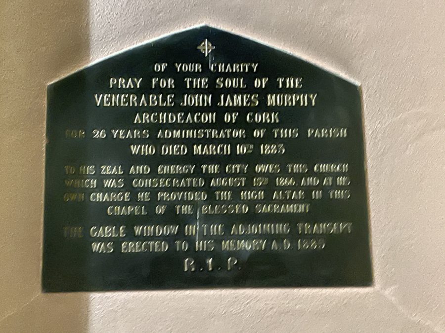
SS Peter’s and Paul’s Church:
The first stone of the Church of SS. Peter & Paul was laid on the Feast of the Assumption, 1859. With designs by Edward Welby Pugin, the architect created a structure full of interesting details. From the use of marble in pillars to the wooden carvings of angels and the confessional boxes, many details are quite striking. They were supported by Parish Priest Fr John Murphy.
Within the body of the Church, there are columns of either side of the nave. There are five of these on either side forming eight arches. The bases of all these columns, are formed of black marble, obtained at the mouth of the Shannon at Foynes. Over these the plinths and columns rise, in polished red marble, obtained in County Cork, from the locality of Churchtown, and up to 1866 was almost entirely used for mending roads.
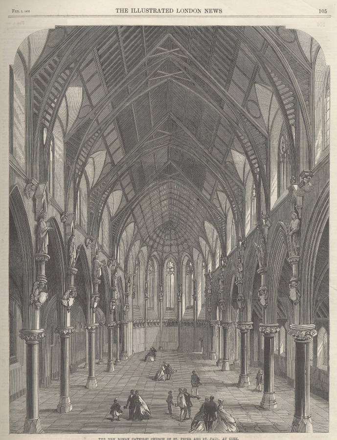
The other pillars in the Church, round the side altars, and under the choir, also are carved; round the Sanctuary, in white Sicilian marble and Galway green, and, under the choir, in red marble, quarried in Little Island, County Cork.
The three altars, the grand and two side altars are objects of great beauty and interest. It was after a number of years that the grand altar was supplied. This was due to deficiency of resources, but according to the Cork Daily Reporter, the temporary altar in 1866 was a carefully decorated and handsomely constructed piece of workmanship. It was decorated in pure white and gold, representing purity and charity, and even with the surrounding grandeur of the church, looked fitting and suitable. It was proposed in 1866 that when the permanent grand altar was supplied, it would be built only, of the purest white statuary Carrara marble which would cost from £l,500 to £2,000.
The dome of the Apse or the altar area, by which it is surmounted, is a marvel of art. It is pointed and decorated in the manner we have indicated-one of pure symbolism and which yet never departs from any rule of artistic beauty. Its blue ground, indicating the sky-its golden decorations, consisting chiefly of the various emblematical figures of the keys and sword of SS Peter & Paul, and pelican, the cherubim and seraphim-and the golden specks to represent the stars moving is deemed a rare delicacy of execution.
Beautiful carved statues of the Twelve Apostles are around the church, resting on corbels, consisting of angelic figures, surmounting the pillars and between the archways on the opposite sides of the nave or the central aisle. Each of these is a gift from some generous Catholic family in the City, and in the arms of the angel supporting each corbel, is a shield containing the arms of the respective donor of each, painted in colours. The benches of the church are of pine, with open backs, moulded tops and ornate rails and ends.
VISIT the Church website here: Saints Peter and Paul’s Church | Cork, Ireland (saintspeterandpaulscork.org)
VIEW the interior of Saint Peter and Paul’s Church, Cork by Kieran McCarthy
SS Peter and Paul’s Infant School:
The National Inventory of Architectural Heritage notes this very ornate building and former school was built in 1879-81 as part of an interesting pair – the other being a presbytery – with the adjoining building to the east. The contractor was John Delaney and when the school opened in 1881 it was to host over 740 pupils.
The architect was Robert Walker (c.1835-1910). The Dictionary of Irish Architects record that from 1850 to 1854 Robert served as a pupil with Alexander Deane and John Benson. His practice was a diverse one, which included a large volume of commercial and industrial work in Cork, some domestic and some church work, the latter chiefly for the Methodists. Many of his commissions were for buildings in the city and county of Cork or for Cork-based businesses which had branches further afield. Two other buildings of note Robert worked on was the Capuchin Friary on Fr Mathew Quay in the 1880s and Cork City Hall in the early 1890s.
READ more about Robert’s work here: WALKER, ROBERT [4] – Dictionary of Irish Architects (dia.ie)
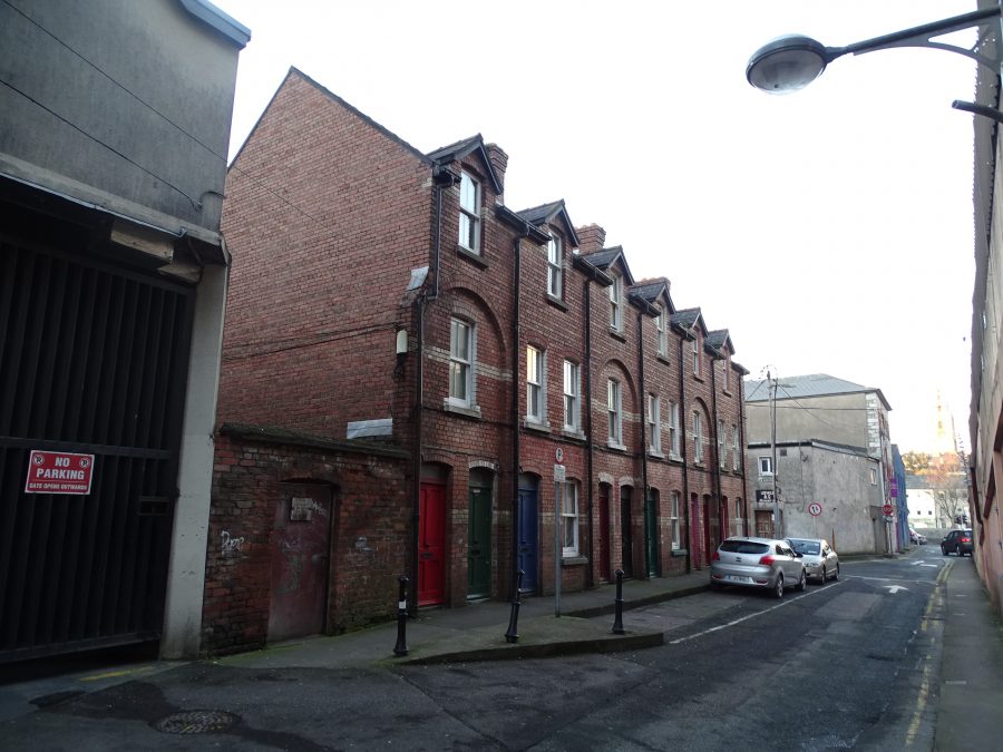
Corporation Buildings:
Set back behind Paul Street and off St Paul’s Avenue are the Corporation Buildings. These terraced three-bay three-storey apartment building were built in 1900. Post the official laying of the foundation stone by Lord Mayor of Cork, Daniel Hegarty on 21 November 1901, the Cork Examiner journalist in his report a day later remarked that the Corporation Housing that had been constructed such as Madden’s Buildings and Roches Buildings were of “good design” but they carried with them the drawback of being rather too “far removed from the working centres”.
Bearing this in mind, the council decided to try the experiment of tenement dwellings in the busy portion of the city. They availed of the Harpur’s Lane market , already Corporation Property, on which they decided to erect eleven three-storey bouses in flats. Each house was to contain three families – three separate and distinct dwellings in one building. A total of £5,940 was spent on their erection. The contract was being carried out by Messrs E & P Flynn, Builders.
French Church Street:
The north-eastern marshes became a significant area of development for the Huguenot congregation in Cork. By the eighteenth century in Cork, over three hundred Huguenots had established themselves in Cork city. Many of them worked as trade peoples especially in the textile industry and in the manufacture of linen and silk.
The Huguenots were also involved in property development and one of the first Huguenot families to develop property was Joseph Lavitt whose family were primarily involved in overseas trade and sugar refining. Lavitt’s Quay was constructed in 1704 and echoes the Huguenot’s past presence in the area.
LISTEN to an interview with Sarah Fawsitt, marine archaeologist with Norway’s National Maritime Museum, who is looking after a 300-year-old Cork shipwreck found off the Norwegian coast. The ship belonged to the Lavitts, a Cork based Huguenot family, https://www.rte.ie/radio/radioplayer/html5/#/radio1/21901696
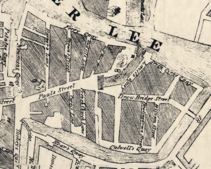
The areas of present day French Church Street, Carey’s Lane and Academy Street in the city centre today are located at the core of the Huguenot quarter. The name “French Church” reflects their involvement in townscape change in Cork in the early eighteenth century.
The growing Huguenot community in Cork initially worshipped in temporary locations but by 1712, members were able to build their own church or temple on Lunham Street, now French Church Street. In 1733 they acquired an adjoining almshouse, which they removed, using the area as a burial ground.
For just over a hundred years the Huguenots worshipped in French at their church. At first Calvinist (non-conformist) services were held, but by the 1740s, worship conformed to the Established Church (Anglican). By the early nineteenth century most Huguenot descendants no longer needed language services. Huguenot worship at the French Church ceased in about 1813.
The French Church was used for primitive Wesleyan Methodist worship for most of the nineteenth century. In 1845 the original building was replaced by a new larger chapel that extended from French Church Street to Carey’s Lane. From about 1901 the building was used for commercial purposes. The last known burial took place in that year.
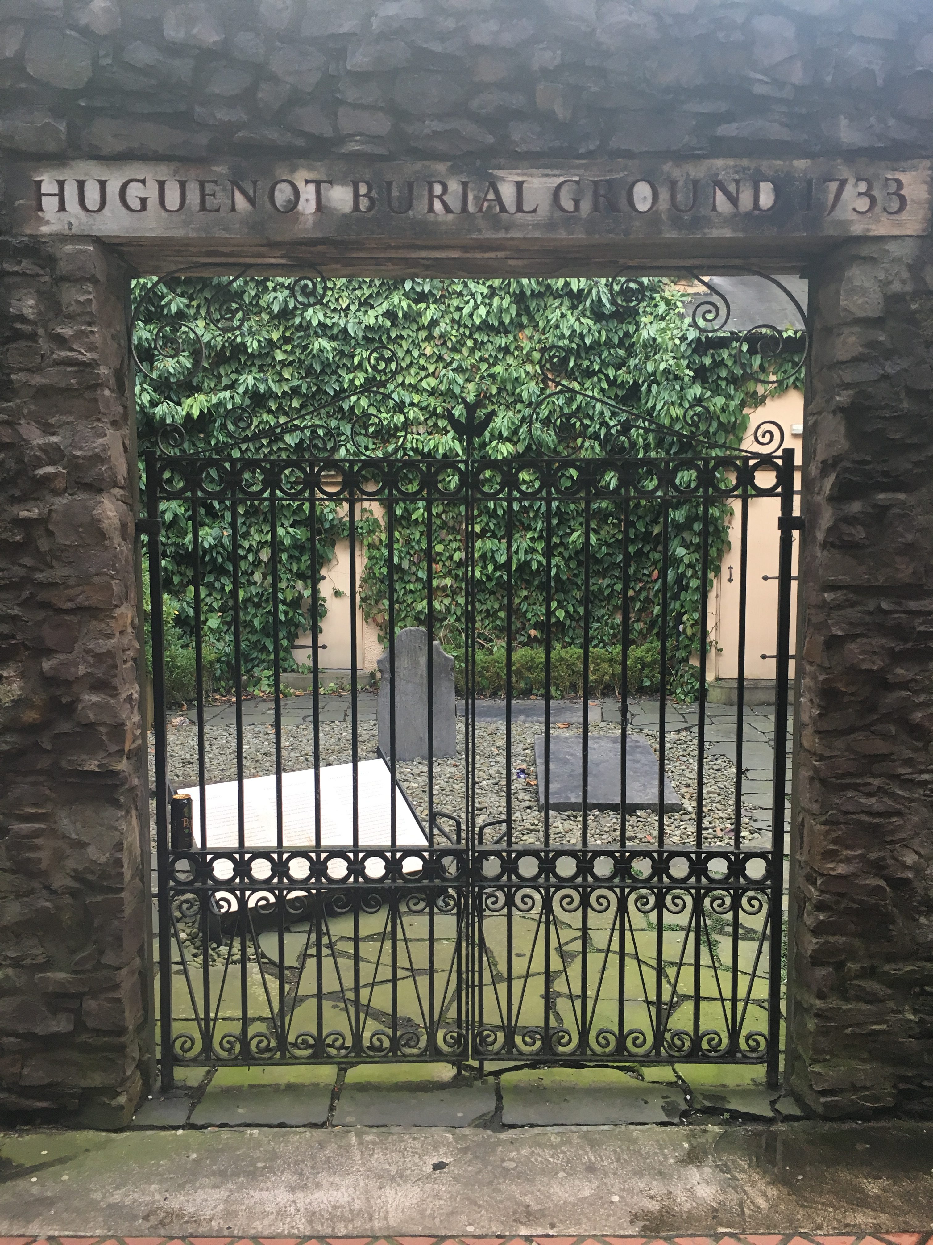
The Huguenot Burial Ground, Carey’s Lane:
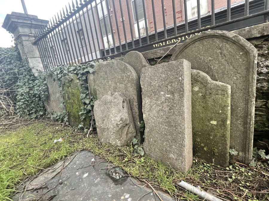
This surviving portion of the burial ground has been preserved as a tribute to the Huguenots who made an important contribution to the life of Cork. It was acquired by Cork City Council in 2007 and transformed into a memorial garden during the following year. Two headstones had survived and when removing debris built over the years, archaeologists discovered other headstones and the remains of tombs. These marked the burying places of Huguenots and their descendants. Methodists also were interred here from the nineteenth century.
Unfortunately, the church and burial records have not survived. Some of those known to be buried here included members of the following Huguenot families – Goble, Hardy, Jappie, Le Grand, Madras, Malet, Perrier, and Pique. Protecting the burial ground from the street is an early eighteenth century wall, dating to the period when this area was settled.
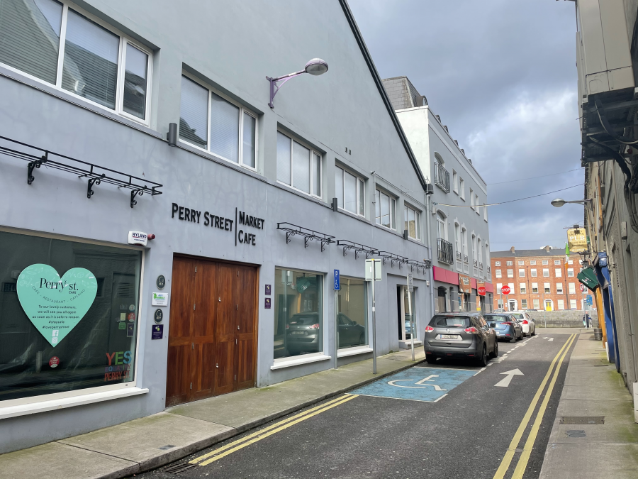
Perry Street & the Sailcloth Heritage:
On 1 June 1726, Douglas Factory was begun to be built. Huguenot members Samuel Perry and Francis Carleton were the first proprietors. They were also members of the Corporation of Cork. The eighteenth century was the last golden age for wooden sailing ships, before the 1800s made steam and iron prerequisites for modern navies and trading fleets. It was a golden age too for maritime exploration, with the voyages of James Cook amongst others opening up the Pacific and the South Seas. Samuel Perry’s legacy is remembered in the name Perry Street, where once he has his warehouses for his sailcloth to be exported from the city’s quays.
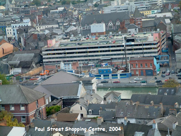
Paul Street Shopping Centre:
On 11 June 1985, Paul Street Shopping Centre was officially opened by Lord Mayor of Cork Alderman Liam Burke. The Developers, O’Callaghan Properties Ltd, sought to help re-vitalise the city centre by providing more and better car parking facilities and by doubling the amount of food retail space in major stores in the city centre. One hundred and fifty jobs were created during the construction period and 200 new permanent jobs created in the complex itself.
Apart from the supermarket, the seventh Quinnsworth store to be built in the Cork area, the development also comprised 14 smaller, retail units and a first floor restaurant.
The new centre was compared with the Pompidou centre in Paris. In fact the interior design work was carried out by a Frenchman, Gerrard Lacour.
The five storey 850 space car park was officially opened in June 1984 and was the city’s first multi-storey car park.
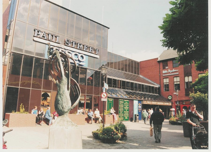
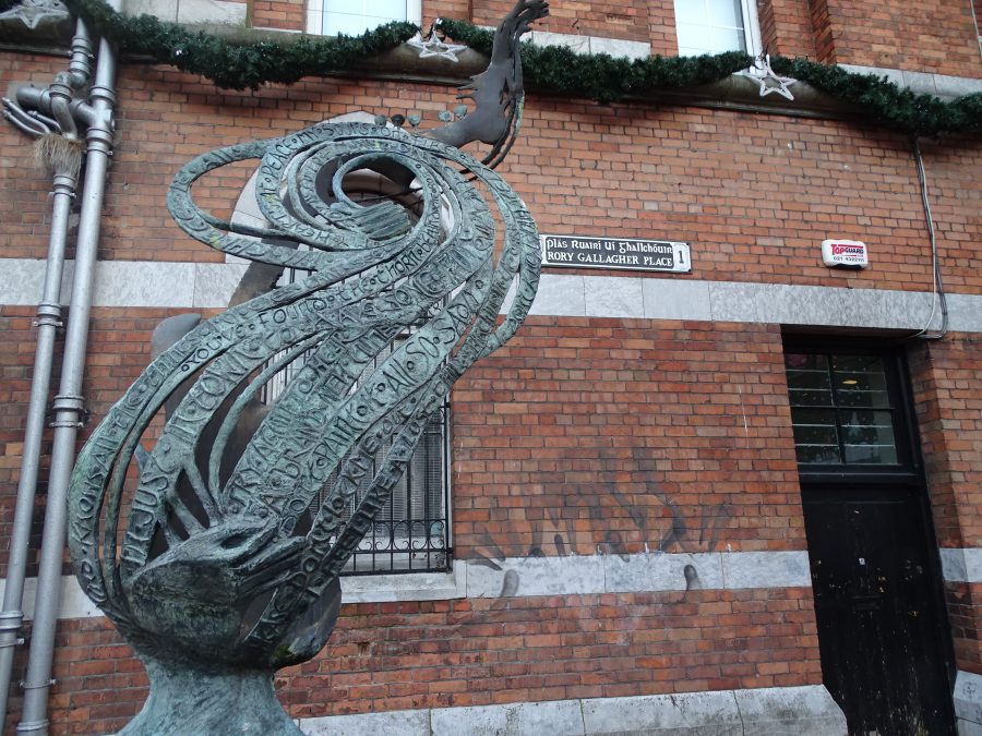
Rory Gallagher Memorial:
In 1997 Paul Street Plaza was renamed Rory Gallagher Place and a memorial sculpture to Rory’s memory was unveiled. The sculpture, by Geraldine Creedon, has a guitar on one side, while the other side contains interwoven lyrics from Rory’s Jinx album.
Rory Gallagher, Musician (1948-1995), although born in Ballyshannon in County Donegal, he grew up and was educated in the heart of Cork City. He pursued his passion for music as soon as he heard the sound of Chuck Berry, Little Richard, Carl Perkins, Lonnie Donegan and Elvis Presley on the valve radio, and later listening to American Forces Network where he heard Woody Guthrie, Leadbelly and Muddy Waters.
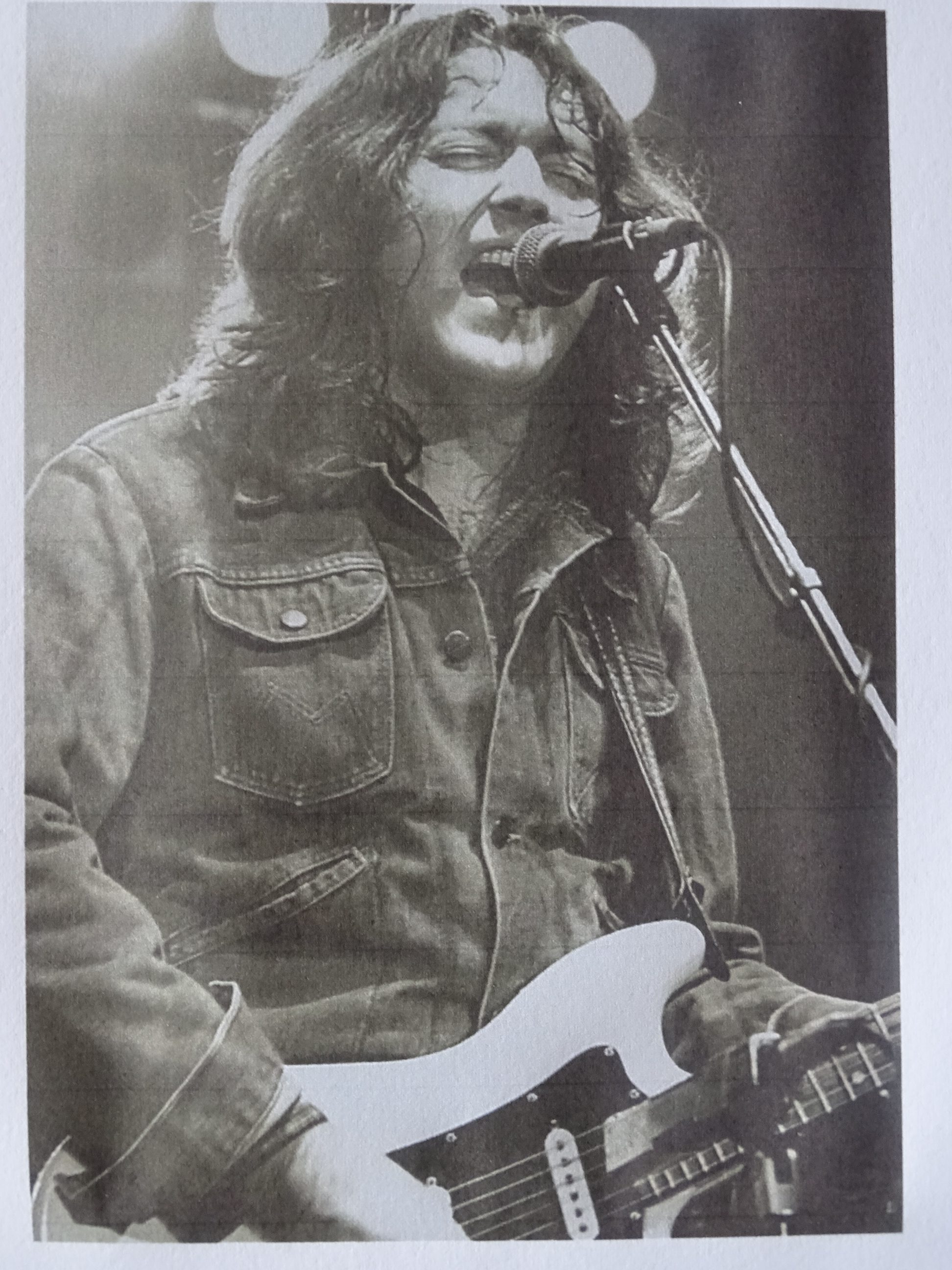
Rory was a self-taught musician and mastered the acoustic guitar in his early teens progressing to his renowned (1961) Fender Stratocaster Guitar – a Sunburst Model purchased (2nd hand) at the age of fifteen from Crowleys Music Store in Cork in 1963 for one hundred pounds. He acknowledged throughout his career the major influence that the music of African American musicians such as Muddy Waters, Howlin’ Wolf, Buddy Guy, Big Bill Broonzy, Blind Boy Fuller, Son House and Tampa Red had on his repertoire both on and off stage.
During his career Rory sold over 30 million albums worldwide and has a major following in Germany, Austria, Switzerland and Holland. The interest in his output has grown since his untimely death in June 1995 with tribute shows in Spain, USA, Sweden, Scotland, Holland, Wiesbaden in Germany, Cork and the Annual Tribute Festival in Ballyshannon, Co Donegal.
Rory’s death on 14 June 1995 came as a great shock to both his fans and his extended family. He was a private individual, a rare and great talent, and a huge loss to the world of popular music, blues and rock and roll.
LISTEN to Rory Gallagher on the Late Late Show in 1988:
https://www.youtube.com/watch?v=cY1J13MlxSY
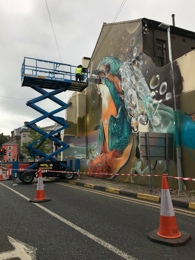
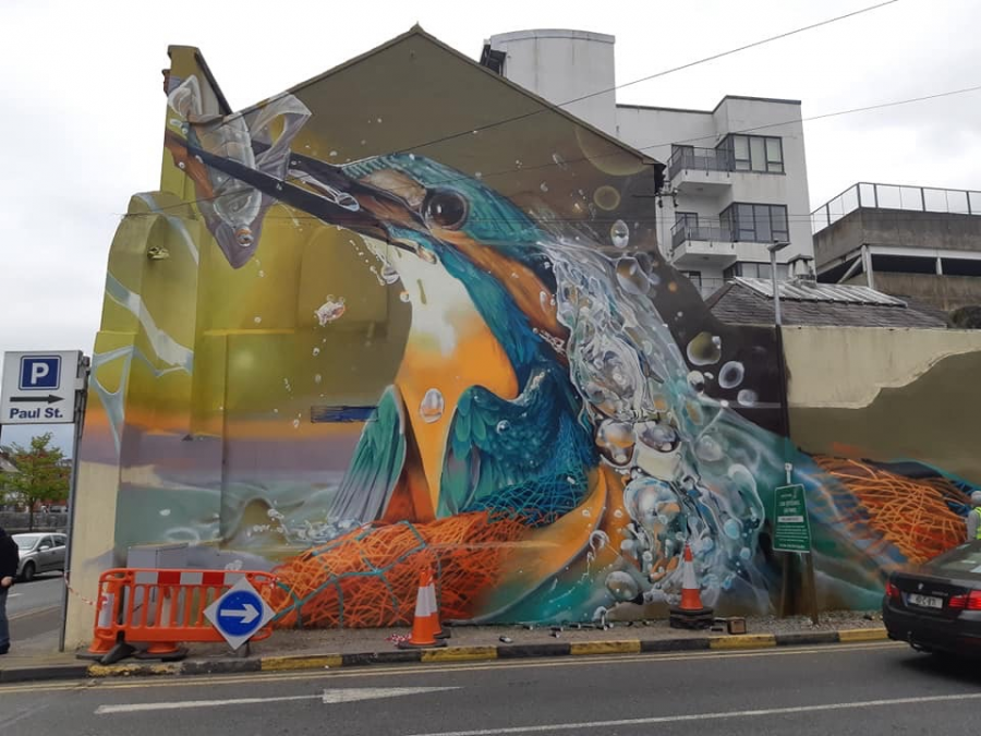
The Kingfisher Mural:
In May 2019, a stunning new mural with a conservation theme was unveiled at the entrance to Paul Street car park as part of a new city placemaking initiative.
The image is of a kingfisher with a piece of plastic. The project is the product of a partnership between the Walls Project, the creative agency behind the annual Waterford Walls International Street Art Festival, and Blackrock Castle.
London artist Curtis Hylton is behind the work. In addition to his work in Cork and Waterford, Curtis has exhibited work in Faro, Glasgow, Bristol and other parts of the UK. His work is primarily focused on environmental themes.
READ the full news article on the piece by Kevin O’Neill here:Stunning kingfisher mural unveiled in Cork city (irishexaminer.com)
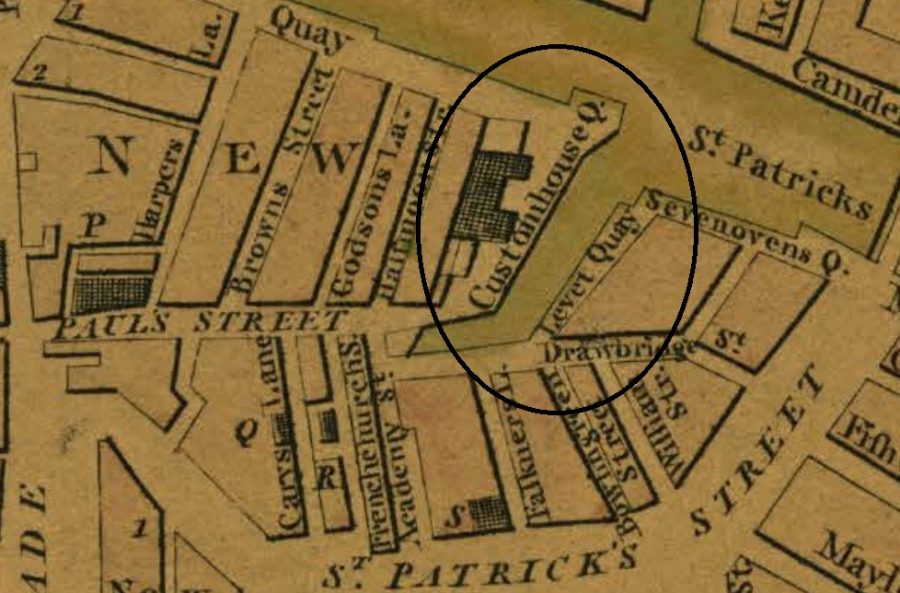
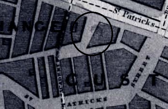
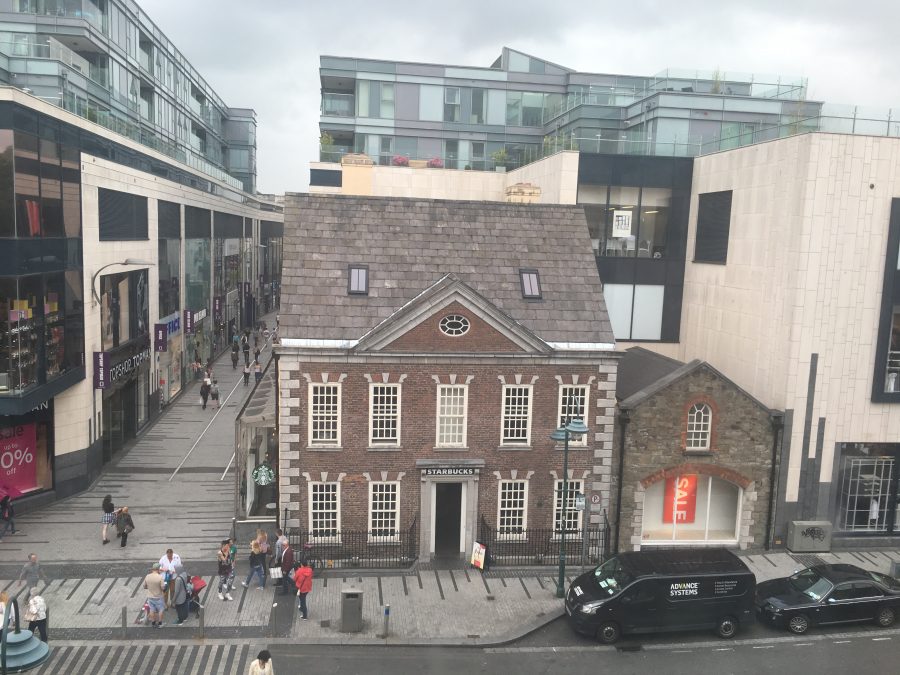
Eighteenth Century Custom House:
In 1724, the Corporation of Cork decided that the old Custom House was too small to accommodate the extent of municipal trade. It was located at the eastern tip of the island of the north east marsh. A new brick building in 1724 replaced that Custom House and was constructed at the expense of the English Parliament. It was surrounded by a “small harbour, a good quay with cranes and all proper conveniences for loading goods and close to the north channel of the river” .
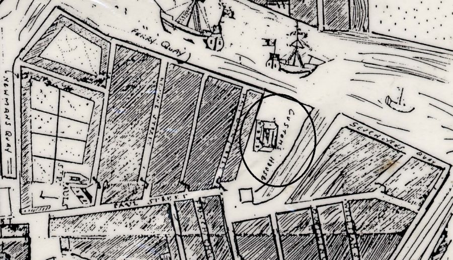
The Custom House, constructed in 1724 was a three-storey building with five bays with limestone surrounds to the windows and triangular pediments over the first floor windows (Power, 1994). In mid July 1727, Mr. John Hawkins, a town merchant and former sheriff of Cork (1707) was granted permission to enlarge the street, yet unnamed (now Paul Street), which led to the new Customs House near St. Paul’s Church.
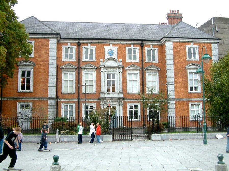
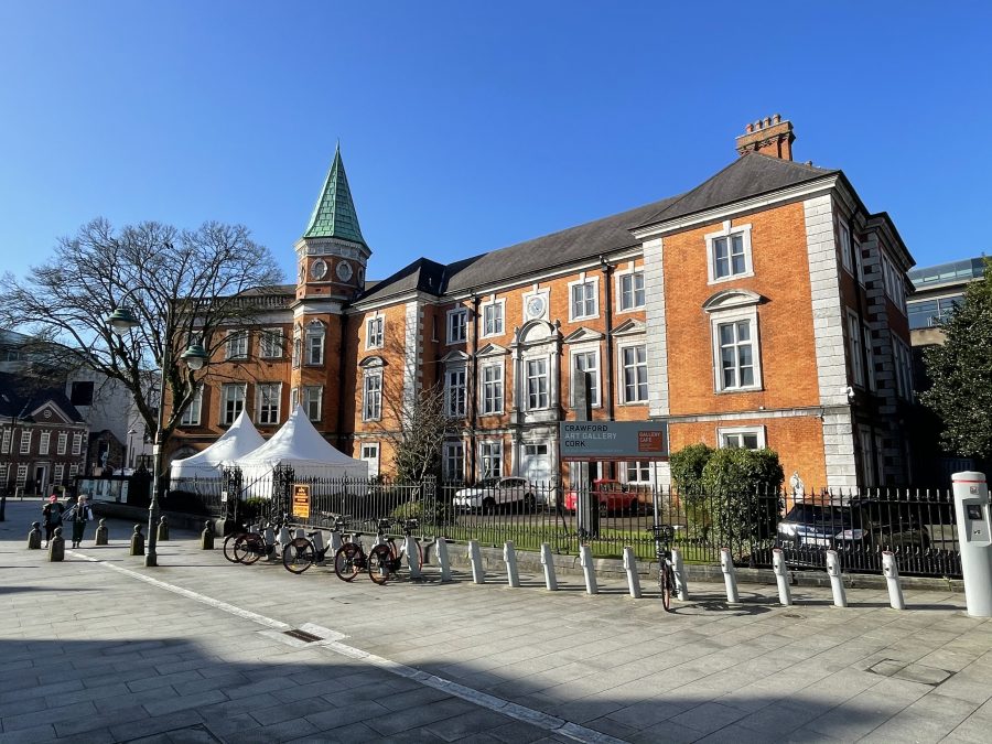
The Custom House (est.1724) was vacated by customs in 1814 and became the premises of the Royal Cork Institution in 1827. In the 1880s the building was refurbished and large extension was built on its southern side. Subsequently, it became home to the Crawford Municipal Art Gallery.
Lavitt’s Quay to Nelson Place to Emmet Place:
Sometime between 1801 and 1832, Lavitt’s Quay and open channel in front of the Custom House was filled in and a formal plaza named (Admiral) Nelson Place was created. At a meeting of Cork Corporation on 18 March 1898, the name of Nelson (Admiral Nelson) Place was changed to Emmett Place. The name change was to mark the centenary of the United Irishmen. It followed the name change of Nile Street to Sheares Street, which took place some weeks previously at a Cork Corporation meeting.
Robert Emmet was an Irish nationalist, patriot and rebel leader. He led a rebellion against British rule in 1803. Having to abort it he was captured, tried and executed for high treason against the British King George III.
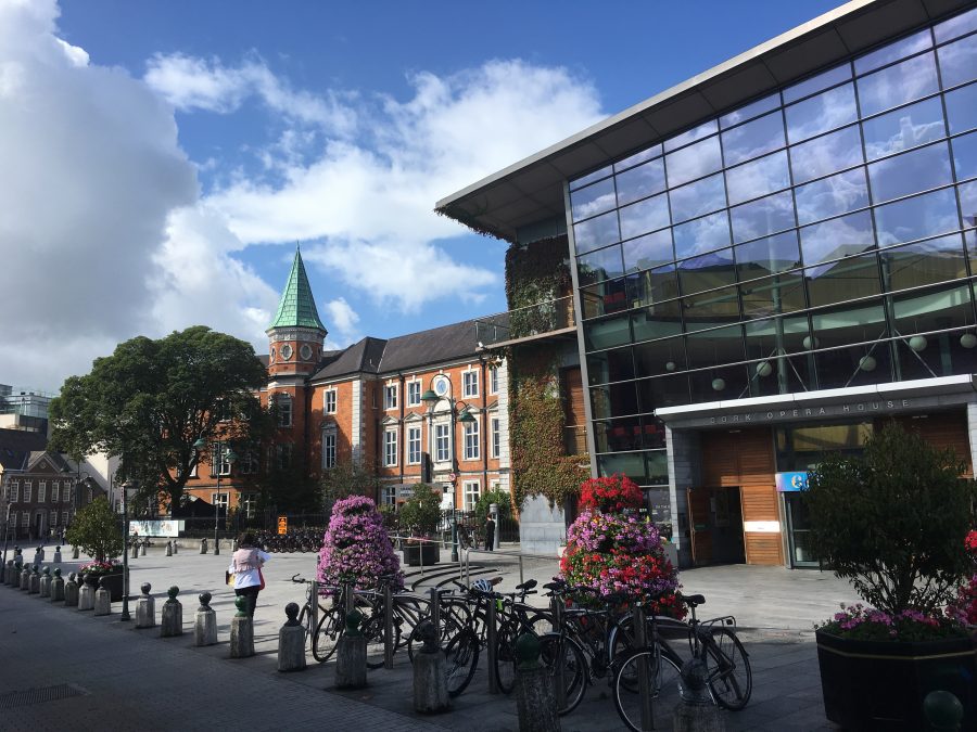
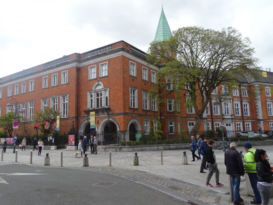
Crawford Art Gallery:
On 24 March 1876, a committee was appointed at a public meeting held in the Royal Cork Institution aiming to establish Schools of Science, Art and Music in Cork. School headmaster James Brennan and architect Arthur Hill were the honorary secretaries of this committee.
In the 1870s, Irish art schools became celebrated for their excellent education in art and design but were criticised for providing a limited education to their student, indeed stopping just short of the point where many students needed encouragement to make the art world their profession. The condition of the School of Art building in Cork was also criticised for its poor physical structure.
The Cork committee in 1878 further proposed the acquiring of old houses between the School of Art and Half-Moon Street in order to construct a new building adjoining the Old Custom House, which would accommodate the Schools of Science, Art and Music together on the one site. Brenan believed that the necessary alterations and additions would cost £6,000 and that £2,500 he hoped would be raised through public subscription. The need for new premises was also highlighted after the visit of Edward J Poynter in November 1880, who was Director for Art in South Kensington, London.
William Horatio Crawford, a prominent city merchant, was persuaded to donate the necessary finance to complete a renovation and extension of the existing School of Art at a cost of £20,000. Arthur Hill of the architect firm of Hill & Co designed the renovated building and extension. The architectural firm was renowned in the city for its use of good quality Victorian building work.
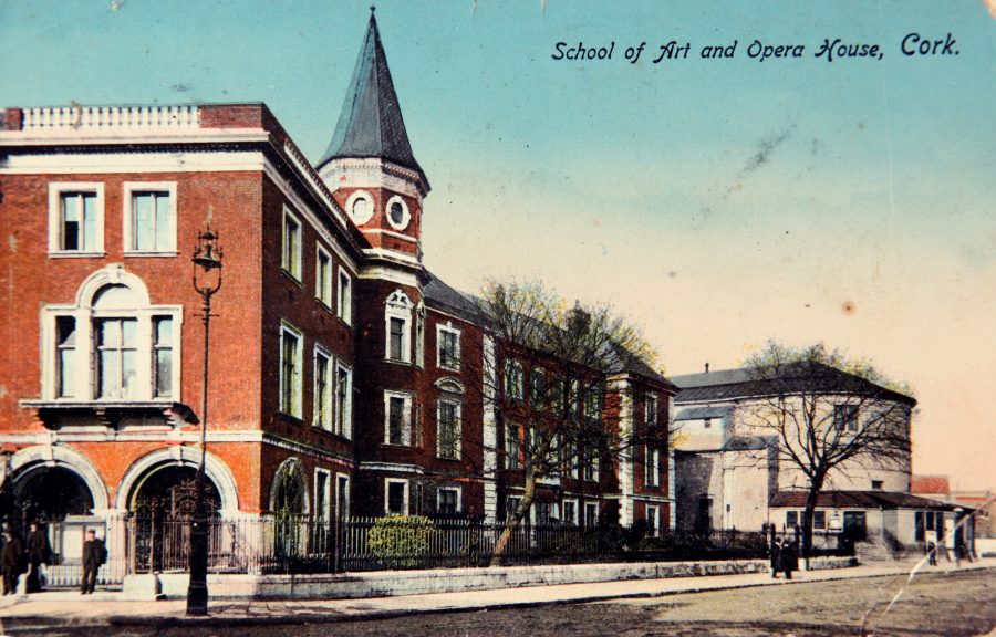
It was originally proposed by the Cork committee that the extension and additions would include a School of Art and Science, and the wrought iron gates, still visible today at the entrance to the Crawford Art Gallery, bear the inscriptions, “Art” and “Science”. The roof was to be complete with several turrets. The initial intention was also to have art and technology taught under the one roof through the creation of an art museum and a science museum. Due to cost factors, many of Arthur Hill’s designs were scaled down. The exterior roof was to have only one turret, still visible today, and which marks the joining of the old eighteenth century Custom House and the new School of Art and gallery extension.
The wrought iron gates at the entrance to the new School and gallery building bear the date 1884, the year the extension and renovation were completed. The official opening ceremony was held on 15 April 1885.
WATCH a short video on the Crawford Art Gallery:
The Canova Casts:
The site of the statue of the Evening Echo on St Patrick’s Street seller marks the site of former offices for the Cork newspapers, Cork Examiner and Cork Evening Echo and the former early nineteenth century Apollo Theatre. In the second decade of the 1800s, the acquisition of the classical casts of Antonio Canova was an important contribution to the cultural status of Cork. Circa 1810, Pope Pius VII was anxious to express his gratitude to the English people for the return to the Vatican Galleries of many masterpieces looted by Napoleon Bonaparte,
Thus, the Pope commissioned Italian artist, Antonio Canova, to make a set of over one hundred casts from the classical collection in the Vatican. In 1812, the casts were shipped to London as a gift to the Prince regent, later George IV. The Prince showed a lack of appreciation towards his papal acquisitions and they lay firstly in the London Custom House and then in the basement of his residence in Carleton Gardens.
Lord Listowel of Convamore, County Cork, a patron of the arts and a friend of the prince suggested that the casts should be donated as a gift to the people of Cork. Agreeing, the Prince donated them to the Society of Fine Arts in the city, whose premises was located on the intersection of St. Patrick’s Street and Falkener’s Lane.
However, shortly afterwards, the Cork Society of Fine Arts, suffered financial difficulty and could not pay the rent of the premises in which the casts were kept. Under considerable embarrassment, they applied to the government for monetary aid. The Westminster government and under the recommendation of the Lord Lieutenant of Ireland stated they could grant no aid but recommended them to amalgamate with the Royal Cork Institution.
An arrangement was made that the Royal Cork Institution, an adult education body founded in 1803, should attain the casts and pay the debt of £500-£600 that was contracted by the Society of Fine Arts. A compromise was made of £300 and the casts were moved to the Institution’s premises on Jameson Row. In contemporary terms, several of the casts can be viewed today in the Crawford Art Gallery.
WATCH: When Heritage Smiles Back, Starring the Canova Casts at the Crawford Art Gallery, Cork, by Kieran McCarthy
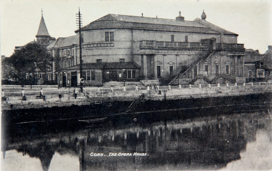
Cork Opera House:
In ensuing months after the 1852 Cork National Exhibition, the President of the Royal Cork Institution, Thomas Tobin formed a committee for converting the use of the Great Exhibition Hall as a venue for promoting culture, the fine arts and practical sciences. John Benson’s iron and glass designed exhibition building was to be transferred from its site overlooking the south channel of the River Lee to the present-day site of Cork Opera House overlooking the north channel of the Lee.
As a lecture and assembly hall, the uses of the new Cork Athenaeum were limited and in 1874, when the ownership of the building came into the hands of James Scanlan, he remodelled it and added a 700-seated concert hall. In addition, he changed the name to the Munster Hall or Halls. Remodelling made stage performances far more practical but the premises was more suited to concerts.
On 17 September 1877, Cork Opera House opened its doors to begin its long illustrious career as Cork’s principal theatre. Mr C J Phipps of London was commissioned to design the Cork Opera House. The Munster Hall was soon to change with two balconies added and a very fine stage. The decorations of the theatre were entrusted to the architect to Mr Edward Bell of London.
The Opera House opened on 17 September 1877 with a performance of H J Byron’s comedy, Our Boys by William Duck and his company. The first manager of Cork Opera House, James Scanlan operated under a board of directors acting on behalf of a private limited company, which had been formed. Fundraising events were common in the 1880s. Scanlon, the manger tried everything to raise funds including a balloon ascent from the Cornmarket. During this event, the balloon, which had refused to ascend for the first two days, suddenly decided to do so with the result that two prominent Cork citizens had to walk home from Carrigtwohill, after they managed the balloon.
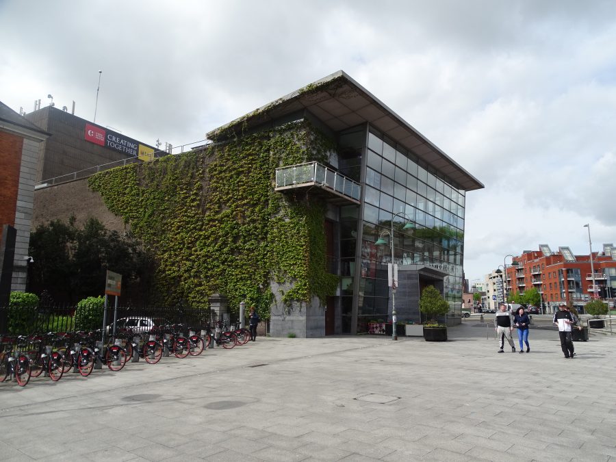
However, the company that was formed in 1877 went into liquidation in 1888. A fresh group of enthusiasts formed a new company with a capital of £12,000 and this was the company, which through all the trials and tribulations was still in existence when the theatre burned down 67 years later in 1955. Cork Opera House was reopened with a new look in October 1965. In recent years, further modifications were made adding a new glass façade and investment into new seating and back stage requirements to host productions.