Trail begins at Middle Parish Community Centre.
Introduction:
This history trail is about exploring the development of Cork from the walled town into what was known as the Western Marshes. The walk stops at sites such as the Quaker Meeting House to the old Mansion House to sites of old canals and quays.
The trail covers some of the topics on my physical walking tour. The information is abstracted from various articles from my Our City, Our Town column in the Cork Independent, 1999-present day, Cork Independent Our City, Our Town Articles | Cork Heritage
Grattan Street Carpark:
From June to August 1997, the site was excavated under archaeologist Mary O’Donnell in advance of development. The published report in Excavations.ie records that an area of approximately 400m2 was excavated in three cuttings.
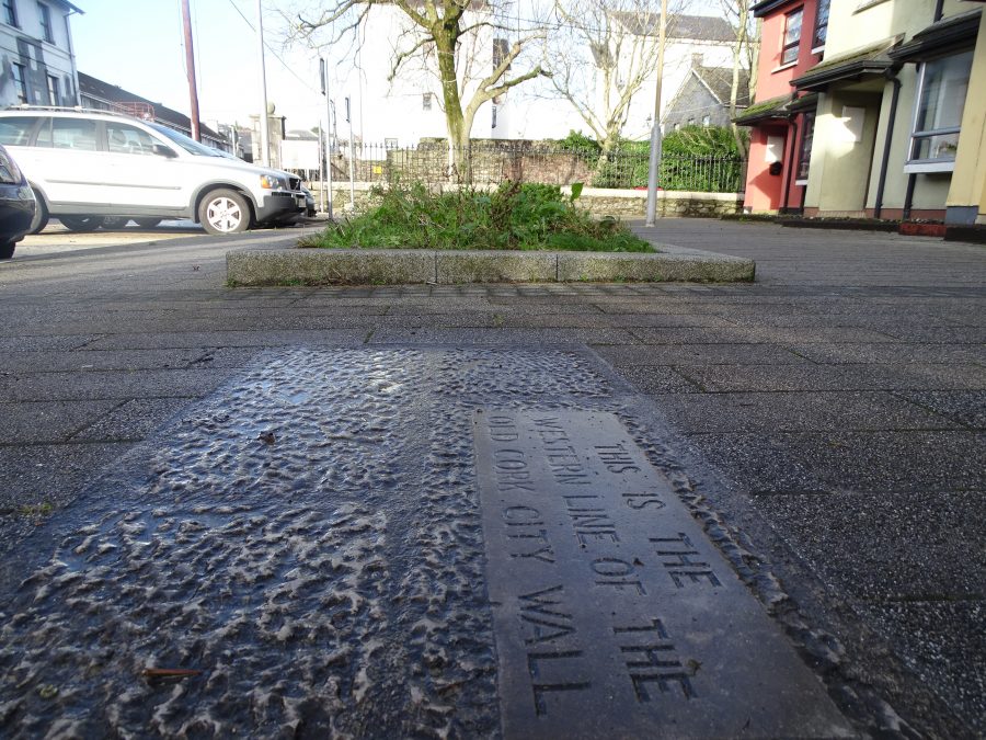
Cutting 1 discovered a 15m-stretch of the western side of the city wall was uncovered. The wall in this area had initially been constructed in the late thirteenth/early fourteenth century and was rebuilt in the 17th. There was a gateway through the wall in the seventeenth century, leading from Philips Lane onto the modern Grattan Street.
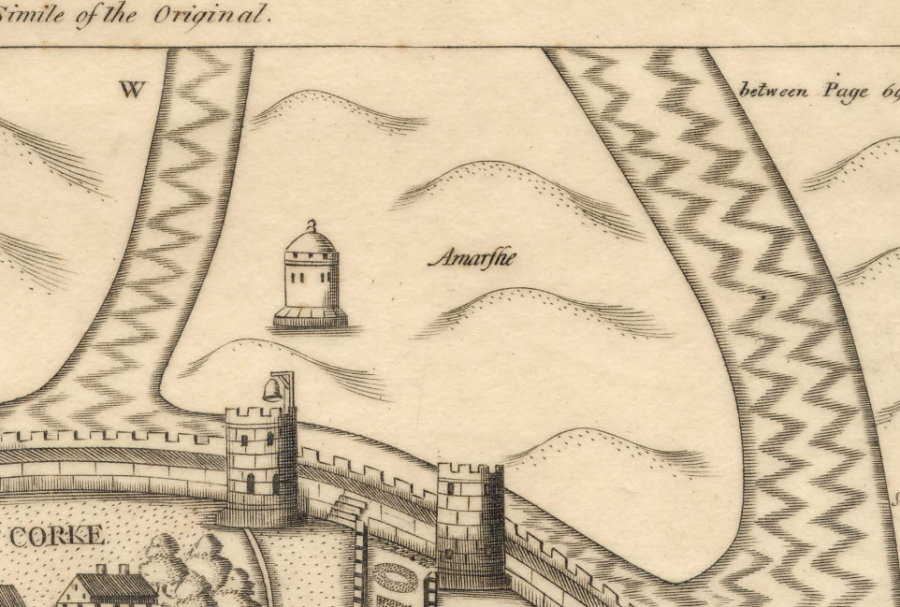
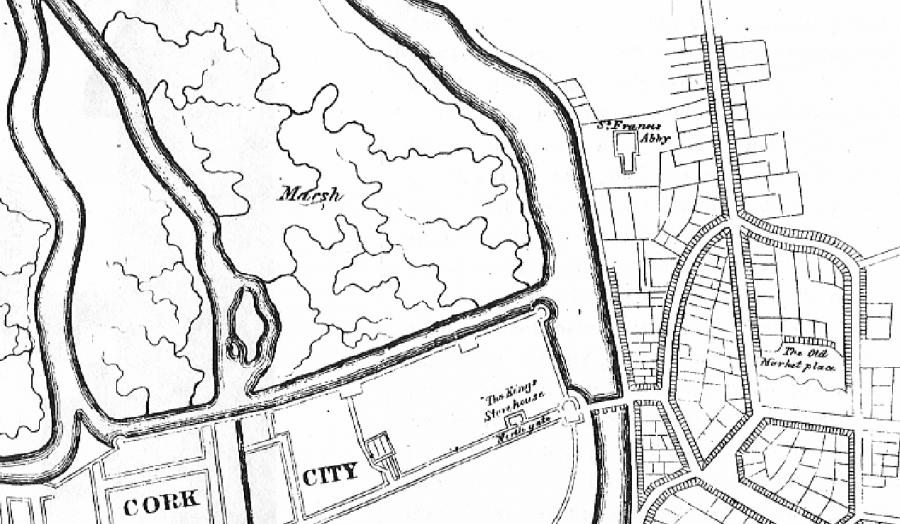
George Carew Map of Cork 1601 shows a watch tower on the western marshes whilst Storey’s Map of Cork in 1690 just shows undeveloped swampland.
EXPLORE: Excavations in Cork City
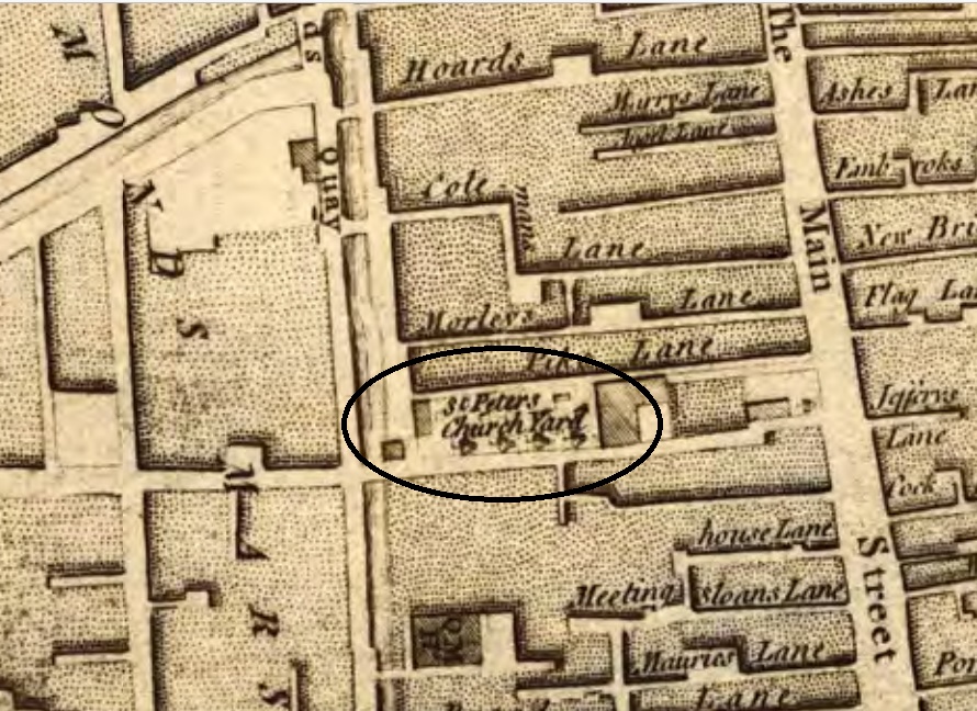
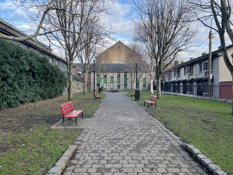
St Peter’s Graveyard:
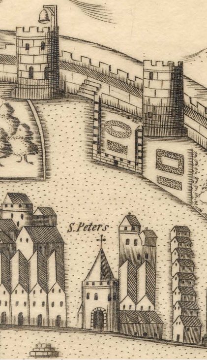
Now a deconsecrated space, this historic graveyard was attached to the medieval parish church of St Peter. The church building is now an exhibition centre and the graveyard is in use as a public amenity space.
In 1750, Charles Smith in his History of Cork in 1750 recorded that some of the gravestones had ‘dates as old as the year 1500”.
Antiquarian John Windele records the discovery in 1838, of numerous tombstones belonging to the “olden era of this Church, forming the foundations of the building which preceded its present steeple. shows to what uses the ancient remains connected with this building have been converted”.
Certainly, the site has undergone modification and possibly significant disturbance to underlying deposits. Burials within the church would have been substantially dislocated during the demolition works of 1782 and the construction of the present church.
During renovations to the church building during the 1990’s skeletal remains were uncovered beneath the floor.
Since 1975, Cork City Council has maintained the graveyard when it was then laid out as a park.
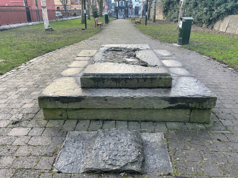
There are thirteen headstones lining the northern boundary wall towards the back of the church. The headstones that are legible date to the eighteenth century. They are not in their original spot
The chest tomb of William Rogers (1686) also remains in its original position in the graveyard.
READ more on Cork City’s Burial Places here published by Cork City Council, https://www.corkcity.ie/en/media-folder/planning/cork-city-s-burial-places.pdf
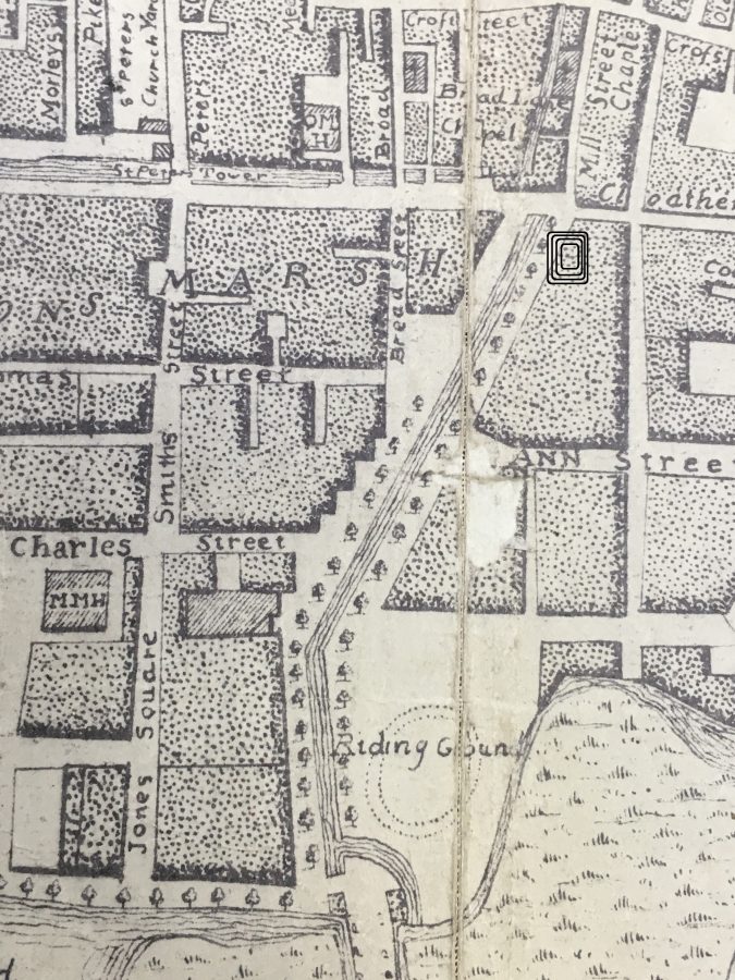
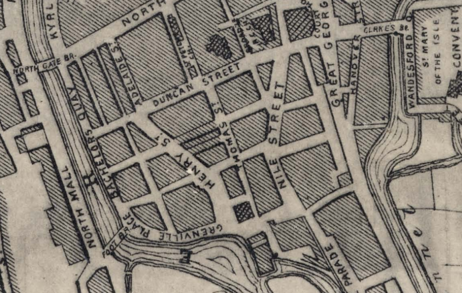
Site of Wall – Eighteenth Century Mapping:
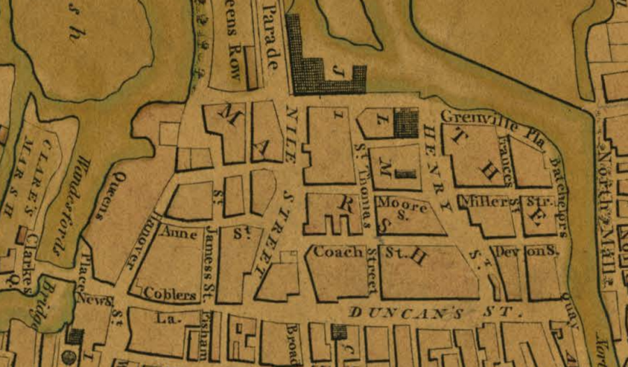
John Carty’s Map of Cork, 1726:
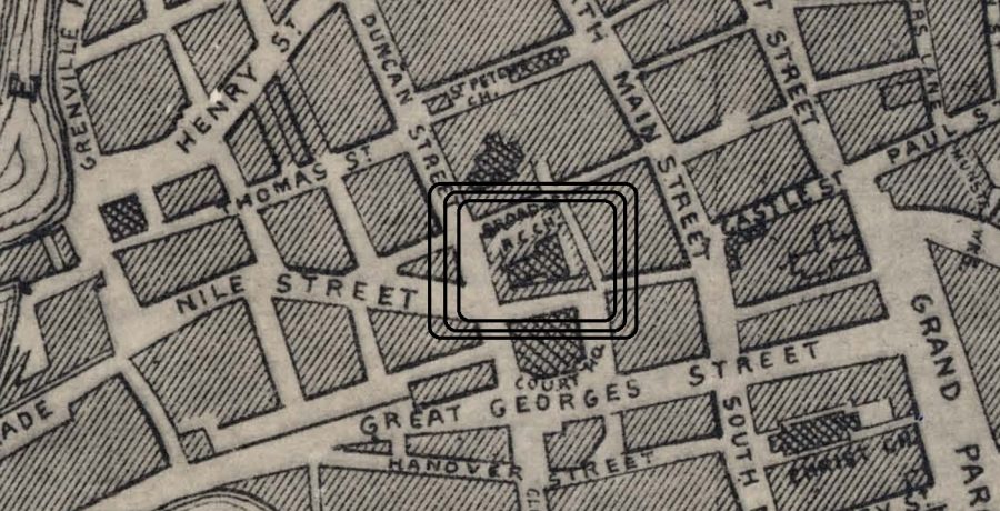
In the period c.1721-c.1730, a useful key to unravelling the changing townscape within Cork is John Carty’s Map of Cork 1726. The map was the first map of Cork produced since Storie’s map of the area in 1690. It realistically shows the transformations in townscape developments.
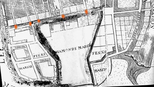
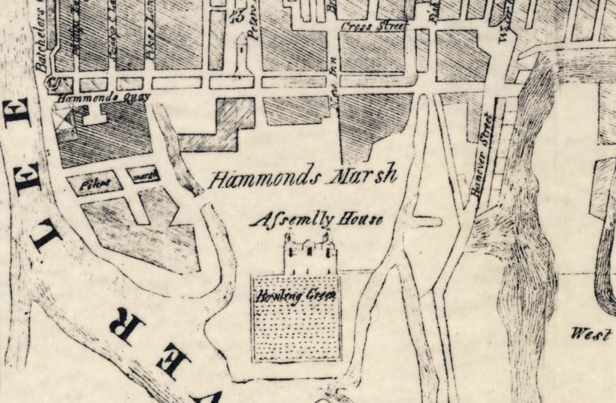
Carty’s map shows clearly the layout of the remaining walls of the town with associated townscape features such as North and South Main Streets and numerous laneways. In the western marshes adjacent to the walled town, the Quaker influence can be clearly seen on Carty’s Map of Cork 1726 with names such as Pikes Marsh, Haman’s Marsh and Fenn’s Marsh appearing for the first time.
Pikes Marsh though seemed to be the more developed of the two. Improvements comprise residences, quays and associated streets. Pike’s marsh was divided into what appear like five empty large plots of which two were fully developed and another only half developed.
Haman’s Marsh was not urbanized except for the area closest to the walled town, then the area of the Quaker meeting house, in today’s context occupied by the Middle Marsh Community Centre.
Fenn’s Marsh had been divided into empty plots but had not been developed yet. Just south of Fenn’s Quay, Hanover Street was detailed.
The developing western marshes were connected to the walled town through what seemed like three stone arch bridges (in red) and bridges were located at the western end of Philip’s, Skiddy’s Castle, and at Hoare’s Lane. The waterway, which separated the medieval core and the western marshes is presently (2003) the location of present day Grattan Street.
Charles Smith Map of Cork 1750:
In the period c.1731-c.1760, as indicated on maps such as Charles Smith’s plan in 1750 there were continued residential, bridge and quay developments in the marshes to the west and east of the walled town.
A bowling green is located on Haman’s Marsh. The Green was surrounded by trees, which formed a private walkway.
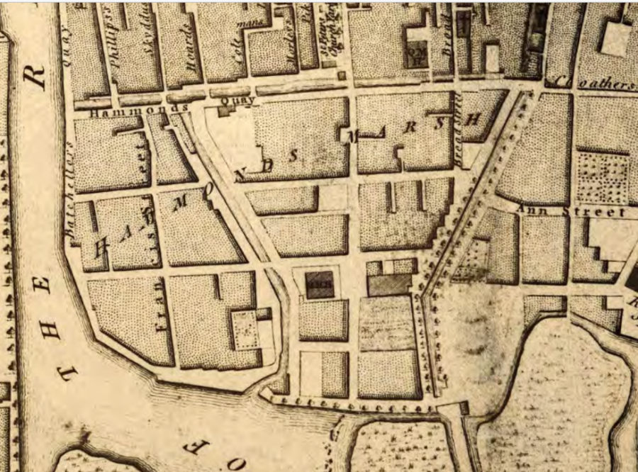
John Rocque’s Survey of Cork, 1759:
In Rocque’s Survey in 1759, Pike’s and Haman’s Marshes are shown as completely laid out with streets. The Assembly House and Bowling Green are no longer shown.
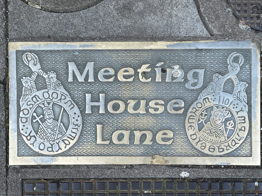
Quaker Meeting House:
The impact of the Quaker community in Cork is documented primarily by local historian Richard Harrison (c.1985 and 1999). He outlines their arrival in Cork and how select individuals of prominent families such as the Pikes, Quakers and Hamans were responsible in physically developing much of the marshes to the immediate west of the walled town of Cork.
In Cork, the first Quakers settled in the town in 1655 when Elizabeth Fletcher and Elizabeth Smith arrived to take up residence. The first church was on a laneway off North Main Street near the Town Cross on North Main The Quaker movement also established itself in Bandon, Skibbereen, Charleville and Youghal.
Cork Quakers possessed a large amount of capital along with a trade or skill that could maintain it. They were people of wealth and thus of status. In particular, they specialised in the manufacture of clothing but did venture into other businesses in other manufacturing industries as well such as sugar refining.
The Quakers generally conducted business between each other but did possess contacts among the Catholic and Protestant merchant classes. However, they did not become over dominant merchants in their respective trades Indeed, one of the most famous early Quakers with Cork connections was William Penn who emigrated to America and founded Pennsylvania. His father over time accumulated large estates in County Cork and William was to inherit them on his father’s death.
By the late 1690s, the Quaker movement were able to consolidate themselves further in Cork Society when the Corporation of Cork accepted and acknowledged the religion’s presence. This was due to the fact that the Quakers could financially aid the Corporation out of debt. Hence, between 1690 and 1700, several prominent members of the Cork Quaker community were made freemen by the Corporation and accepted into trade guilds.
The first freeman included Ebenezer Pike and Richard Pike. Richard Pike was in partnership with William Alloway, who established the first linen drapery in Cork. Richard’s father, Joseph Pike initially dealt in wool and English goods but when the English parliament outlawed the export of serge to the continent, he turned to the export of Bay yarn to England.
In 1696, Joseph Pike became one of the first Quakers in Cork to pioneer the investment of capital into reclaiming marshland in order to create residences. In that year, he purchased a large portion of an unnamed marshy island just to the west of the walled town.
Other Quaker families soon followed the Pike investment. The Fenn family leased the land from the Pikes in 1705. John Haman, a respected linen merchant, also reclaimed land for residential purposes. He also bought land in the north-western suburbs of the town in the first decade of the 1700s. Other families that invested in land in the early decades of the 1700s were the Devonshire and the Sleigh Family.
All of those names mentioned, named the marshes after themselves. A good example is Fenn’s Marsh. The name ‘Fenn’ still resonates on the present day townscape in the form of the street, Fenn’s Quay, which in the early 1700s was built adjacent a channel of the River Lee.
Apart from developing land, individual Quakers also recognised that the town’s population were in need of finance and offered their service as private bankers. Brothers Edward and Joseph Hoare established the first private bank in 1675. Joseph was married to Rachel Rogers whose sister was married to Joseph Pike. In 1720, Joseph Pike became a partner of the Hoare Bank and after both brothers died in the 1720s, it was the Pike family that continued on the banking tradition in Cork well into the 1800s.
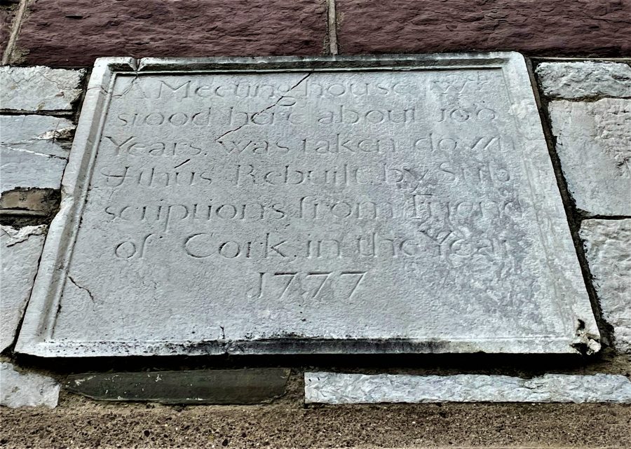
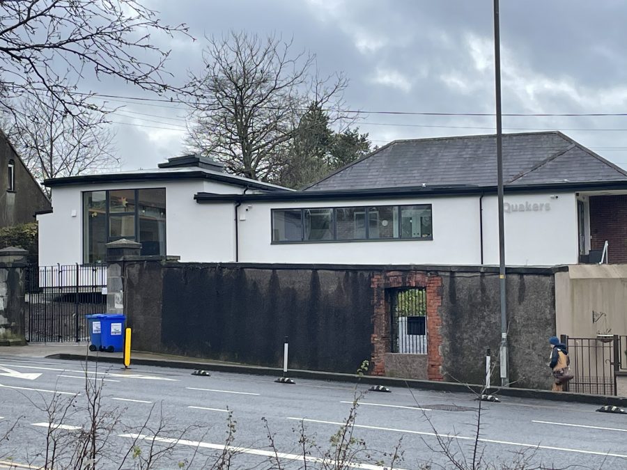
The sixteenth century Quaker meeting house was replaced twice at least (first in 1777 and then in 1833).
The 1833 meeting house was designed by architect G T Beale – an ornate detached six-bay two-storey building.
In 1939, a smaller meeting house was built on Summerhill South adjacent to their early eighteenth century graveyard.
READ MORE HERE: Cork | Quakers in Ireland (quakers-in-ireland.ie)
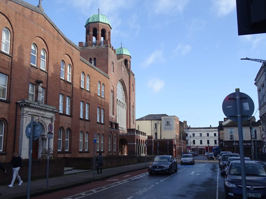
St Francis Church:
In 1540, some English Reformers came to Ireland under the direction of King Henry VIII, in order to suppress monasteries. Unluckily one of their first targets was the North Abbey. The abbey was taken for the King.
Due to their land been confiscated, the majority of the Franciscan friars ended up living with relatives or friends. However, they still ministered to the spiritual needs of the people but on a much quieter scale.
For over a hundred years, the Franciscan Order was scattered around Cork City. They were constantly suppressed and any friary or mass-house they did establish, they usually ended up leaving it and fleeing with their lives from the authorities.
By 1750, the Franciscans had moved from North Main Street and had by now set up a friary in Broad Lane which today is part of the present site of St. Francis Church. In 1771, another move was made by the friars, this time to the opposite side of Little Cross Street (again part of the present site of St Francis Church) where they built a superior church than the last. It was here that they remained until the present day.
In July 1813, it seemed apparent that a new church would have to be built due to the increasing numbers in the congregation and the disrepair of the church. So on 26 July 1813, Dr John Murphy P.P. laid the first stone of the new building on the previous site. The latter friary was taken down and all its contents were sold off. On 14 July 1829, the foundation stone of the new church was laid. Its architect was a Charles Cottrell of Hanover Street.
In the following decades, various items were added to the church. For example, gas in 1855, a new bell tower in 1858, a new high altar in 1865 and a new sacristy constructed in 1876. Plus in 1865 the roof had to be repaired due to the extensive damage delivered by a winter storm.
In 1856, the Parish of St. Francis and SS. Peter and Paul’s Church were joined together.
In the years 1837, 1878, 1892, 1893 and 1894, the Franciscans bought land from Cork Corporation which resulted in the Order acquiring quite a bit of area in front of the friary and on Grattan Street. Also in between the above years, the street in front of the friary was widened, the porch rebuilt, lamps and railings installed and more further improvements to the church and friary were carried out.
A new modern church was ceremonially blessed and opened, four years later on the 14 July 1953 by Bishop Cornelius Lucey.
The new church i.e. the present St. Francis Church is one of the Byzantine style of architecture and its interior is richly decorated with mosaics.
Duncan Street & Grattan Street:
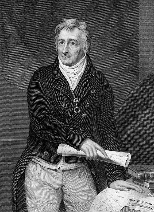
On the filling of the Hammond’s Quay canal and the elimination of its bridges to form a street, the throughfare was named Grattan Street in 1778. Henry Grattan (1746 – 1820) was a lawyer and Irish politician. In the late eighteenth century he campaigned for legislative freedom for the Irish Parliament or home rule from Britain. He was a Member of the Irish Parliament (MP) from 1775 to 1801 and a Member of Parliament (MP) from 1805 to 1820.
However Antiquarian John Windele writing in 1839 noted that in the hey-day of the Volunteers, (1783) public gratitude was expressed to the celebrated Henry Grattan, by giving his name to this street. However shortly after, members of Cork Corporation took umbrage at his conduct on some question of that day, dislodged the name, and in 1798, imposed that of Admiral Duncan.
Admiral Adam Duncan, 1st Viscount Duncan (1731-1804), was a British admiral with a command of the North Sea. On 11 October 1797, he routed a Dutch fleet off Camperdown, Holland. This victory is judged as one of the most significant actions in British naval history. Admiral Duncan was given the freedom of several cities, including Dundee and London.
Duncan Street is marked on all surviving nineteenth century maps of Cork but reference is made in the Cork Examiner to the street be renamed formally Grattan Street again sometime in 1892-1893.
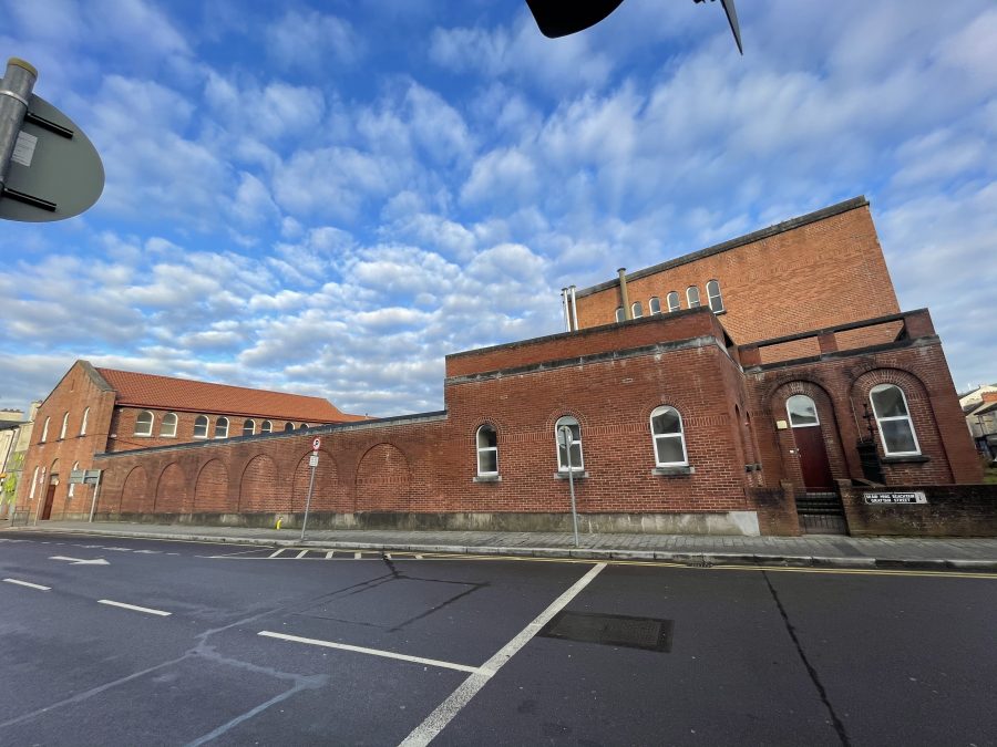
Grattan Street Fire Station:
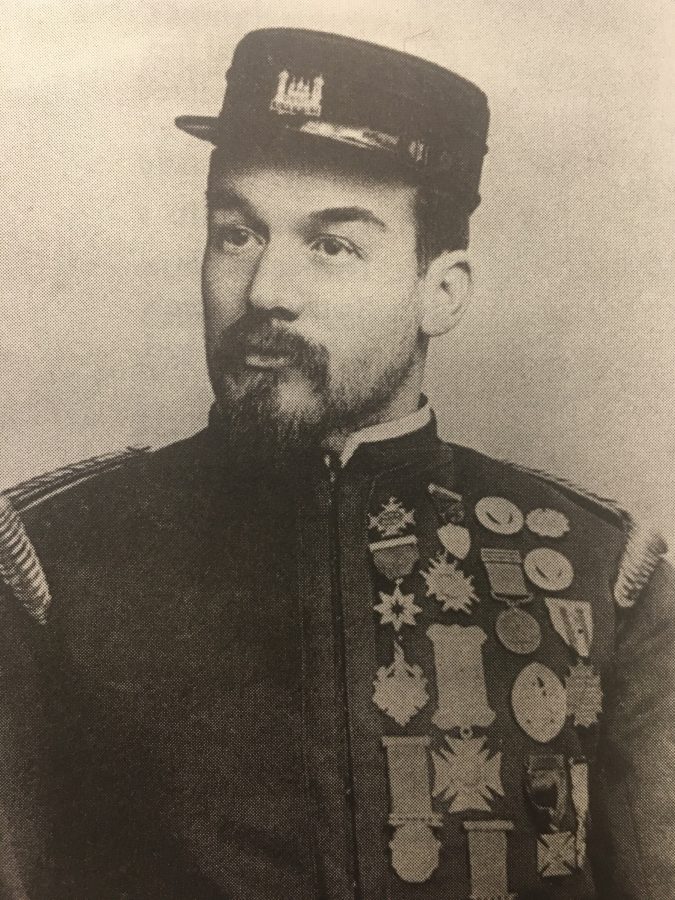
Local historian Pat Poland’s book For Whom the Bells Tolled and Cork Examiner reports through the years reveal that Cork Corporation established Cork City Fire Brigade in 1877. The first fire station was at 20 South Mall, where the Corporation offices were then situated, but it was soon moved to the site at Sullivan’s Quay. Facilities were certainly limited to say the least. The site was an open one with a small office which operated as a duty room.
Captain Mark Wickham who was an inspector of the fire escapes in Dublin had the enormous task of organising the activities of the insurance companies’ brigades while in the South Mall. After a time it became usual for this brigade to respond to any fire calls whether it was an insured premises or not. This arrangement suited the Corporation and lasted from Captain Wickham’s appointment in 1877 until in the late 1880’s when the insurance companies decided they had undertaken too much in accepting responsibilities for everyone’s fires. What emerged was a free service without any public financial aid needed towards the upkeep of the service.
The site at the South Mall remained open up to 1894 and the equipment consisted of a horse-drawn hose reel, a jumping sheet and a fire escape. Captain Wickham remained in office until 1891 when he was succeeded by Captain Alfred Hutson who was appointed Superintendent of the Cork Corporation Fire Brigade. A former station officer in Brighton Fire Brigade and having served in the London Metropolitan Fire Brigade, he was well equipped to handle the problems he encountered in Cork.
In Cork Alfred Hutson first initiated a building and re-organisation programme. He increased the staff to seven men and ten part-time auxiliaries, the latter being selected from Corporation employees. The present Quay Co-Op, now the red bricked fire station at Sullivan’s Quay was built in 1893 during his early years of service in Cork.
The training of the auxiliary staff was undertaken and they were then employed on outside duties such as theatres, bazaars, etc. They were summoned by a system of call bells. Captain Hutson between the years of 1891 and 1894 organised volunteer fire brigades among the students of Queens College (UCC) and in 1892 a volunteer fire brigade of prominent businessmen was also formed.
Two additional fire stations were opened during Captain Hutson’s reign at the rear of the Courthouse on Grattan Street and at the top of Shandon Street. The men were full time firemen in every respect as they were on duty 24 hours of the day seven days of the week. New entrants had to live in accommodation provided on the station premises so in an emergency whether he was on or off duty, the fireman had to turn out for work. The engines at this time were two Merryweather steam pumps, which were drawn by teams of horses and these were purchased in 1892. In St Patrick Street a central street station was located with rescue equipment and one man on duty all night.
In addition, large rescue equipment was located at strategic locations in the City. The Brigade at that time consisted of six regular men and two Turncocks living on the station with six auxiliary firemen, all Corporation employees, and with local volunteers in all a force of 30 men could be mustered in a few minutes. A report from the Chief at the time suggested that a night response took about 2.5 minutes with men fully dressed and horses out.
Explore the history of the Cork Fire Service more with Pat Poland’s book: For Whom the Bells Tolled: History of Cork Fire Service: A History of Cork Fire Service 1622-1900: Amazon.co.uk: Poland, Pat: 9781845889869: Books
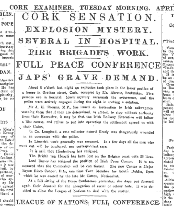
Volunteer Activity on Grattan Street, 1919:
On the morning of 28 April 1919, the site of a Irish Volunteer secret bomb making factory at 33 Grattan Street was rocked by an explosion. It was the location of a three-storey tenement house and of a boot shop run by Andrew Ahern on the ground floor. Michael Tobin, aged about 26 of 15 Batchelor’s Quay, died at the Mercy Hospital on 20 May 1919 as a result of serious burns and shock sustained in an explosion.
The wounded Volunteers were Captain Richard Murphy, Quartermaster Seán O’Connell, Paddy Varian, Timothy Hegarty and Jeremiah Downey. Miss C (Bessie) Moore of Anne Street was the wounded Cumann na mBan member. At this facility haversacks were made, gunpowder was ground, and bombs were assembled.
On 21 May 1919, an inquest was held at the Mercy Hospital where Coroner William Murphy outlined the circumstances of death of Michael Tobin. The results were published in the Cork Examiner. The police authorities and the next of kin’s solicitor appeared. Drs Crosbie and J B O’Regan were present on behalf of the Mercy Hospital medical staff.
A jury was also sworn in. Timothy Ring, of the fire station at Grattan Street, was sworn in. He related that he was on duty next to 33 Grattan Street and at about 8pm he heard the crash of glass and an explosion about 50 yards away. He observed that four or five men passing by seemed to be thrown to the other side as a result of the explosion. He at once rang up headquarters, and having notified them, took a fire reel to the scene of the explosion. He saw through the smoke four or five men, one of whom seemed to have his clothing on fire.
READ more here: Kieran’s Our City, Our Town, 25 April 2019 | Cllr. Kieran McCarthy
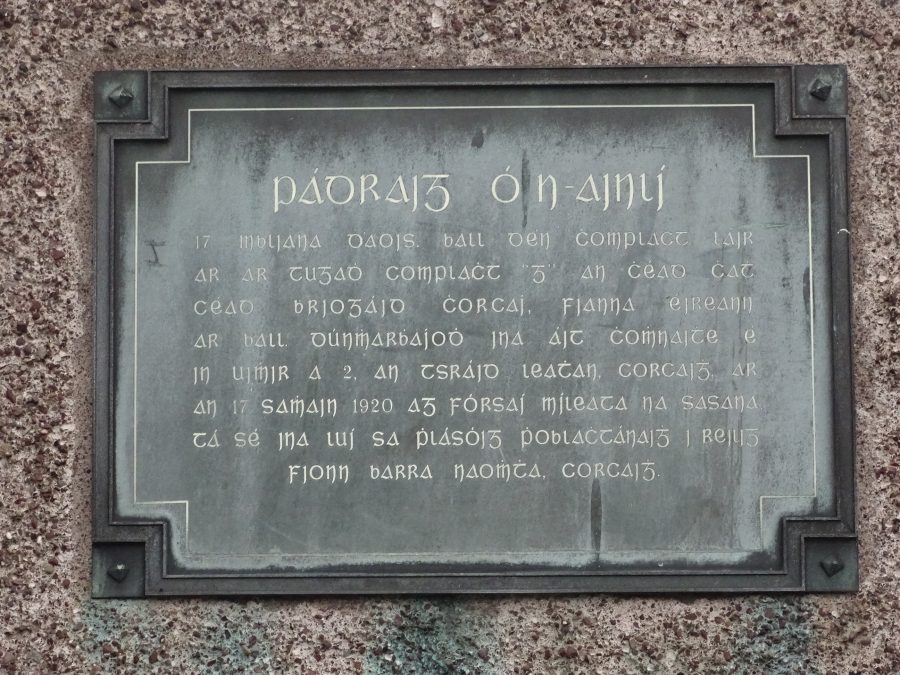
Patrick Hanley Plaque:
Teenager Patrick Hanley was shot by crown forces on 17 November 1920. George Hurley was a comrade of Patrick within Fianna Éireann or the youth division of Cork IRA Brigade No.1. He recalls the lead-up and incident in his witness statement to the Bureau of Military History (WS1630).
The murder of Patrick Hanley was by way of a reprisal by the British for the shooting of an RIC sergeant named O’Donoghue by G Company of the IRA earlier on the same night of 17 November 1920 in the course of an IRA raid on Lunham’s bacon factory.
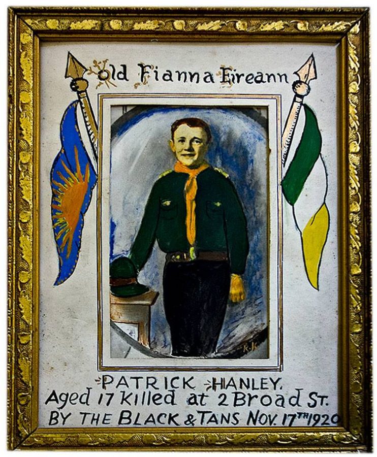
Patrick lived with his widowed mother at No. 2 Broad Street. He was the sole support of her and his sister. At about 11.45 p.m. on the night of 17 November 1920, the residents of No. 2 Broad Street were awakened by the noise of the front door being broken open; a man rushed up the stairs and entered the bedroom of Mr and Mrs Coleman who also resided in the house. The man was wearing a policeman’s uniform, cap and goggles. He came to the bedside with a revolver in one hand and a flash lamp in the other.
When asked by Mrs Coleman what brought him there, he merely exclaimed “Hello”, flashed his lamp on the bed, raised his revolver and fired point-blank into the bed. The bullet wounded Mr Coleman in the arm. The assailant then turned and walked out of the room leaving Mrs Coleman screaming.
Patrick Hanley opened the door of his room when he heard the man rushing up the stairs. The man in police uniform had just come from Mrs Coleman’s room. Whilst standing at the door of his bedroom door, Patrick was fired at. It missed him. The man fired a second time and the bullet struck Patrick above the heart, killing him instantly. He was in his night attire at the time.An ex-British army soldier who lived in Broad Lane was also shot dead.
Leo Buckley, Intelligence Officer with Cork Brigade No.1, was a witness of the shooting (WS1714, Bureau of Military History). At the time, he was sleeping in a top back room of an apartment house in Sheares Street. He recalls that some hours prior to Patrick’s death, an RIC Sergeant had been shot by Tommy Healy and Willie Joe O’Brien of G Company. Tommy and Willie were hiding on Sheares Street. Leo denotes in his witness statement that he felt that Patrick had been shot in mistake for Tommy Healy, while the shooting of O’Brien’s brother-in-law the ex-British army soldier was also a mistake.
In another reprisal raid the same night by the RIC in the Grattan Street, another Fianna boy O’Brien was shot in the mouth. He subsequently recovered from the wound. Volunteer Eugene O’Connell was also killed on the same evening as a reprisal for his part in the murder of the RIC Sergeant. An IRA man suspected of giving information as to who shot the RIC Sergeant was later apprehended and executed by the IRA.
Patrick Hanley’s remains were laid out in his Fianna Éireann uniform in the mortuary of the Mercy Hospital and later removed to the church of SS Peter & Paul. He was buried in St Finbarr’s Cemetery, the tricolour-draped coffin being shouldered all the way to the cemetery by the dead boy’s comrades.
At the Republican Plot there are two memorials to his memory – an individual cross and a marble stone to Fianna Éireann.
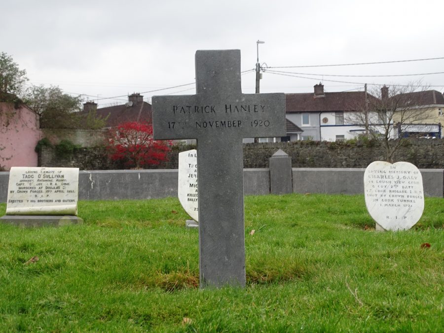
In addition, on 17 November 1957, a plaque was unveiled by Lord Mayor Jago in memory of Patrick Hanley on Patrick Hanley Buildings on Grattan Street. Eugene O’Callaghan’s headstone can also be viewed in the Republican Plot.
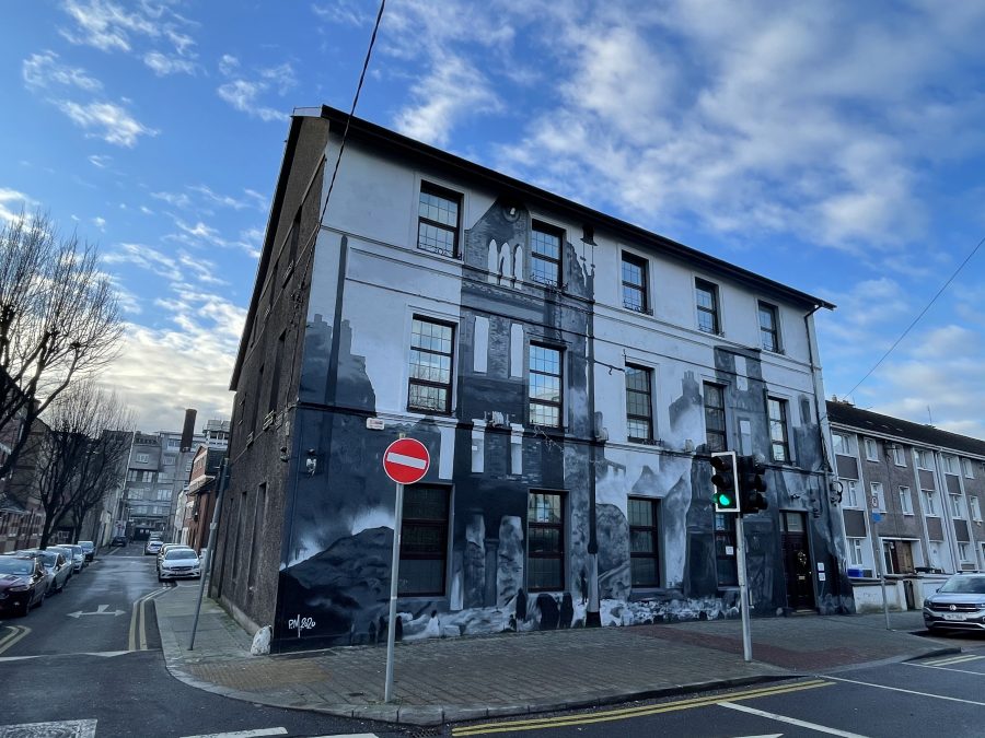
Middle Parish Community Centre:
The Middle Parish Community Association was formed in 1969 with the purpose of catering for the needs of both the elderly parishioners and those of the young. On 11 June 1971 the centre was officially opened by the then Minister for Health, Mr Erskine Childers.
In early March 2020 Peter Martin who has created various works of art around Cork city, which look at Cork’s history and identity, was contacted by George Patterson, Chairman of the Middle Parish Community Centre . Mr Patterson who has been undertaking a research Masters on the history of the Middle Parish had received funding from Cork City Council’s Commemoration fund to create a mural based on the Burning of Cork 1920.
The idea was to give passers by today a sense of what it was like to see their city in ruins, something Corkonians experienced 100 years ago.
READ more: Mural depicting the Burning of Cork gives locals sense of what ‘fellow Corkonians experienced 100 years ago’ (echolive.ie)
FOLLOW: Cork Middle Parish Community Association – Home | Facebook
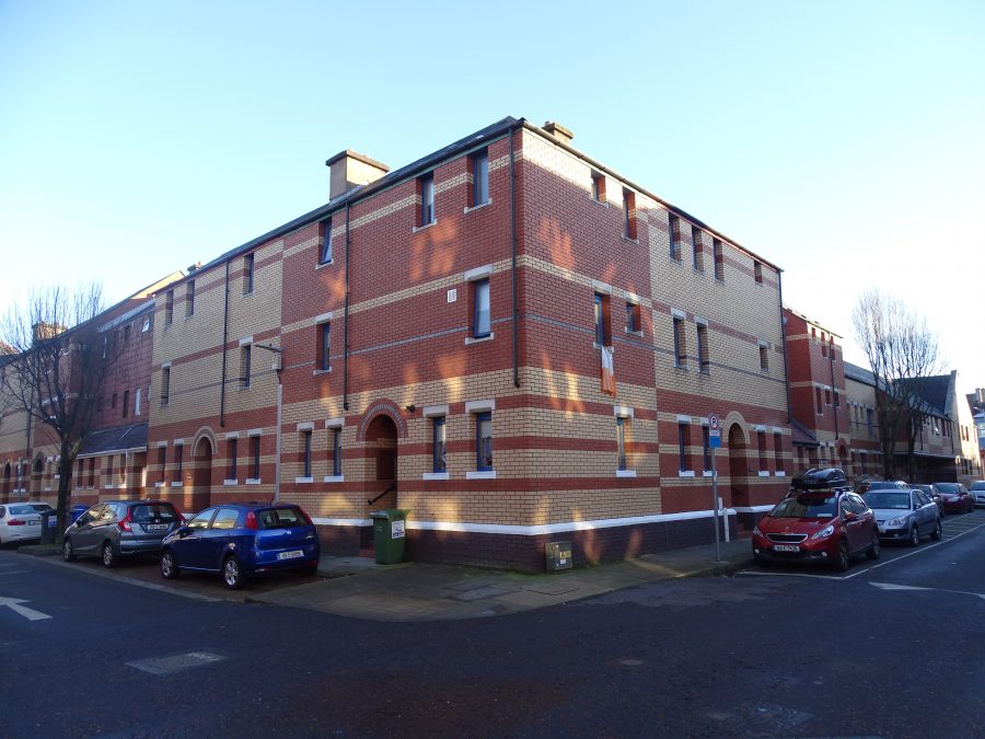
Share Housing:
Established in 1970 SHARE is a registered charity, by students from Presentation Brothers College, Cork, who raised funds to try and make existing housing for Cork City’s vulnerable elderly more comfortable.
The blessing of the foundation for SHARE’S new project in December 1985 on a section of the former car park in Grattan Street, Cork marked another important step in the group’s phenomenal success story. This eleventh project was indeed unique, providing 32 units with an inner courtyard and a shelter within a shelter for the elderly in the community. Perhaps the most important aspect of this is that it gave freedom of movement on one hand while on the other provides adequate security.
At midday, Wednesday 7 December President, Dr Patrick Hillery formally opened SHARE’s newest complex and 150th house in Grattan Street. The ceremony was preceded by a thanksgiving Mass in nearby St. Francis Church 11 a.m. celebrated by Bishop Buckley, Auxiliary Bishop of Cork and Ross.
One of the most well-known elements of the fundraising over the past 50 years is the SHARE Christmas campaign which comprises the annual 24-hour fast and the blessing of the crib in the city. It has become a tradition of the Christmas season in Cork. The crib is supervised by students right up until Christmas Eve to inspire people to donate to the commendable cause. The fundraising effort each year involves student volunteers from 22 of Cork’s schools.
READ more here on SHARE and its work: SHARE | SHARE Cork
WATCH: Thoughts at the Crib, St Patrick’s Street, Cork, December 2020:
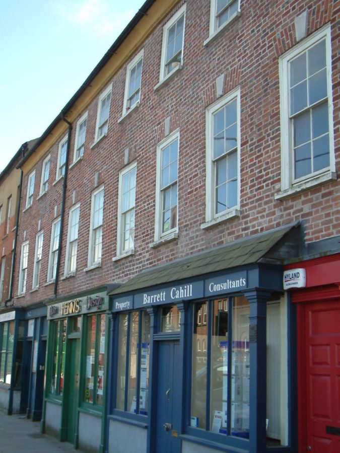
Fenn’s Quay:
The buildings 2-5 Fenn’s Quay comprise the majority of an eighteenth-century terrace with remarkably intact interiors. Cork City Council included the buildings in their Historic Area Action Plan, which obtained European Union funding for their conservation. Cork City Council played a significant role in the conservation process, in both policing the project and suggesting acceptable final users.
Historical research based on the original title deeds and other deeds in the Registry of Deeds established the likely construction date of 1750. Other research traced the evolution of the terrace. A Quaker family appear to the original developers of the site. The plan is unusual in that is a series of parallel angled layouts in response to the dictates of the then river channel rather than the more common stepped facades.
The buildings were originally a single house through all floors with the intervention of shop at ground floor level in the nineteenth century as evidenced by remaining window heads behind the shop fascia. The project was awarded the RIAI Silver Medal for Conservation in 2005.
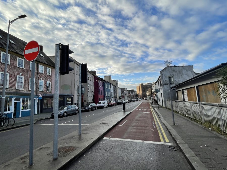
Sheares Street:
Sheares Street was once a river channel and belonging to the Fenn Family. It was filled in 1795 and named Nile Street in 1798:
Antiquarian writer, John Windele, in 1838 describes of Nile Street:
“Nile Street, near the Mansion-House, is an irregular open passage, leading towards the Mardyke; the houses project beyond each other in total defiance of all straight lines, and are in general weather slated in front. The stream which passes beside the “Mardyke,” and through Castle-St., Patrick-St., &c. formerly occupied an open channel through this street, then called Fenn’s-Quay. It was arched over in 1795; and in 1798, to commemorate NELSON’S Victory, was named ” Nile-Street”.
John Windele also highlights The Lying-in-Hospital, in Nile-Street, which was established in 1798, for the relief of poor married women. It contained 12 beds, and in the year 1834, 281 Patients were relieved. Its income in that year, amounted to £416 16s. 5d.
On 4 February 1898, Cllr A O’Driscoll secured a majority amongst members of Cork Corporation to change the Nile Street to Sheares Street to mark the 1798 Irish Rebellion and the execution of Cork Brothers John and Henry Sheares. Henry Sheares, senior, was one of a family who settled in Cork early in the seventeenth century. He was MP for Clonakilty in 1762-8 and was father of John and Henry Sheares. He was partner in a banking institution in Nile Street in 1777. The family resided in a quaint villa at Glasheen, a suburb of Cork.
John and Henry were both lawyers and in 1792, they visited France and witnessed the French Revolution there. On their return they joined the United Irishmen. However, their trust of comrades was betrayed when a spy a Captain John Armstrong betrayed them, when the brothers spoke about revolutionary intentions.
John and Henry were arrested on 21 May 1798 and were found guilty of treason. They were publicly hung outside Dublin’s Newgate Prison. They were buried in vaults at St Michan’s Church in Dublin.
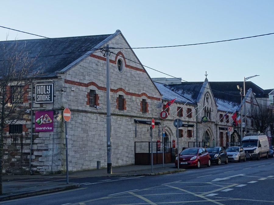
Mardyke Entertainment Complex:
The Mardyke Entertainment Complex was a former bonded warehouse of Woodford Bourne.
This elegant structure was built circa 1830 and later was remodelled in 1876. The carved design and detail of the grey limestone and red brick are impressive.
The materials utilised in the construction of this building, such as the grey limestone and red brick add colour and textural interest to the streetscape.
The archives of Woodford Bourne Company are held in UCC. The introductory blurb details that the Woodford Bourne company can track its beginnings back to a firm of wine merchants named Maziere and Sainthill which was operating in Cork as early as 1750.
In the mid nineteenth century, John Woodford had a grocery shop on the Grand Parade. Mr Woodford died during the Famine, and his widow married a Mr Bourne, an employee of Woodford’s and thereafter the firm was known as Woodford, Bourne & Co.
In 1869, Woodford Bourne purchased the supply of the wine merchant Richard Sainthill and extended the business to incorporate wines.
Woodford Bourne occupied one of the premier sites on the corner of Patrick Street and Grand Parade (currently MacDonald’s). The firm also owned extensive warehouse premises on Sheares Street.
James Adam Nicholson, who was an employee of the firm, eventually became the sole owner. For generations, the business continued in the Nicholson family until its subsequent sale in the 1980s.
In the 1980s, the shop was renovated to a fast-food outlet named ‘Mandy’s’ and the premises was taken over by MacDonald’s in the mid-1980s.
READ more at UCC: Home – Woodford Bourne Collection – UCC Library at University College Cork
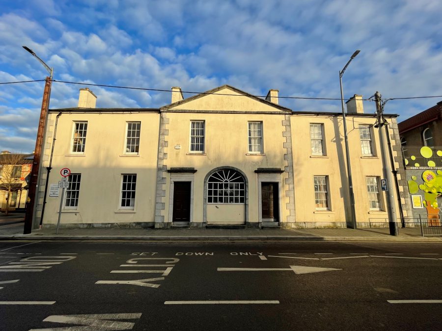
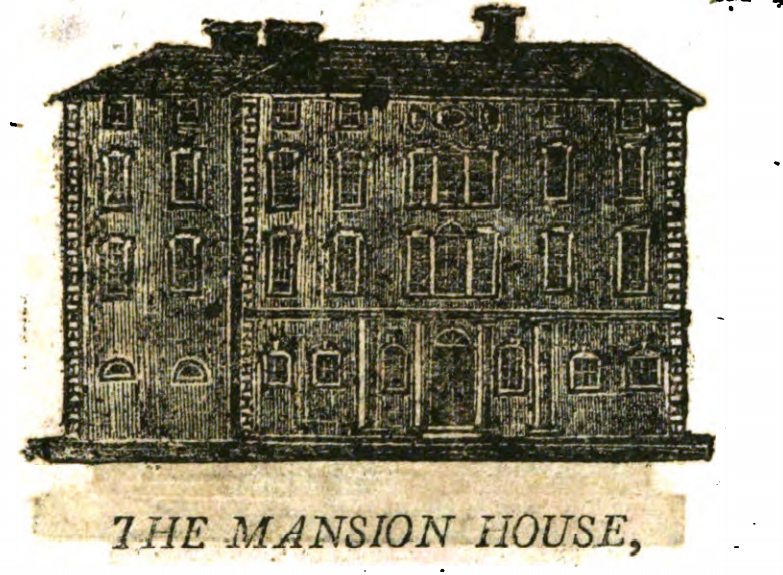
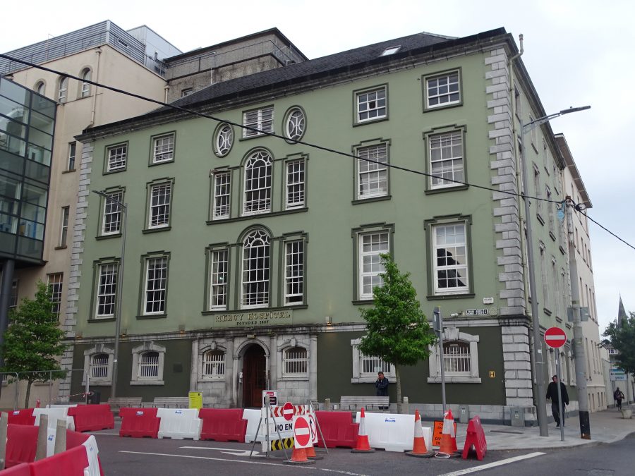
The Mansion House & Mercy Hospital:
The Mercy Hospital was once the site of the old Mansion House. The stone porch and entrance are still standing; so is the magnificent mahogany staircase and one can view the beautiful Frescoed Ceilings on the upper floors. The Mansion House was built in 1767 for a cost of £3,793 with large and expensive dining and sitting rooms. It was designed by the Italian architect Davis Dukart.
In the dining room, there was a full length figure of William III in armour. For years there were grumblings in the Corporation of Cork about the expense of keeping up the Mansion House as a mayoral residence. In March 1842 the bill was £1,000 for repairs and furnishing to make it fit for an official residence.
On 21 June 1844, the Mansion House began a new chapter in its history when the Corporation granted a 75-year lease of the building to two Cork Priests, Rev Michael O’Sullivan and Rev Michael Scully, who created St Vincent’s Seminary at the house. The link to education and charity grew at the site and on St Patrick’s Day, 1857, the Sisters of Mercy embarked on creating the Mercy Hospital at the site. Forty beds were ready on the first day but only six patients were admitted on the first day.
Today the hospital has upwards of 300 beds and employs over 1,000 staff. It provides an array of inpatient, day patient and outpatient services across an array of adjacent purpose-built building.
READ more here on the hospital’s services:Mercy University Hospital – Mercy University Hospital, Cork, Ireland. (muh.ie)
WATCH: Short Mercy Hospital history video produced by Jim Corbett and Mercy University Hospital
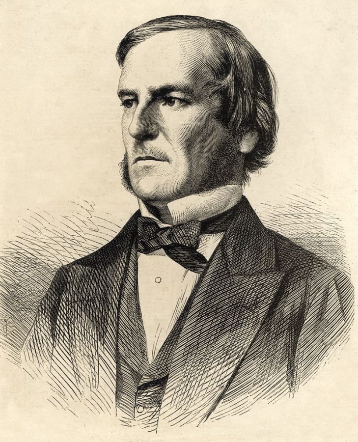
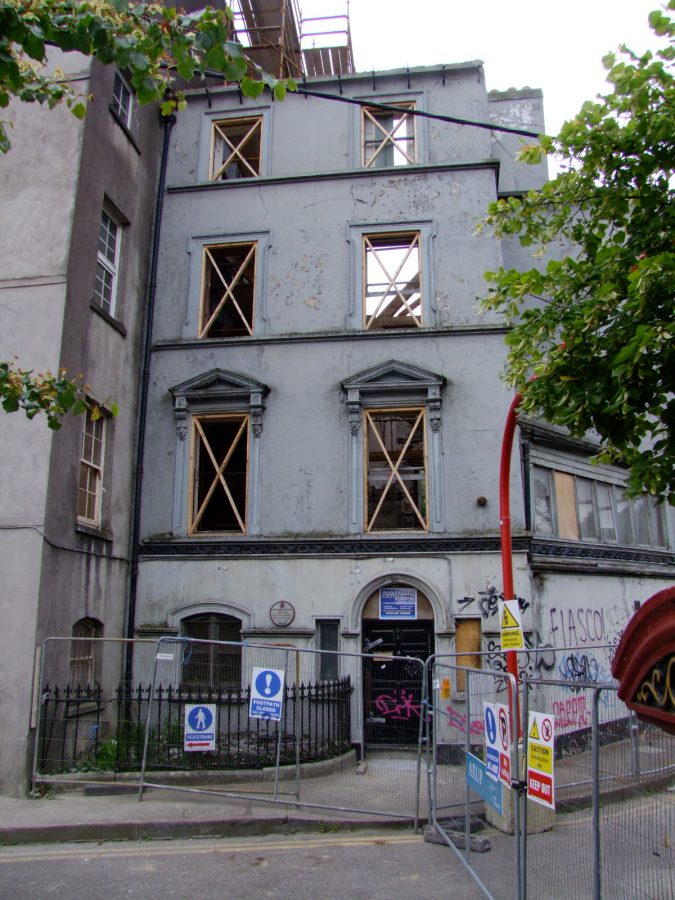
Boole House on Grenville Place:
George Boole is an icon in the history of the world of maths. In 1849 when George became the first professor of mathematics at Queen’s College, Cork, he lodged at 5 Grenville Place.
Within this house in 1854 George Boole signed off on his famous book, The Laws of Thought. The book introduced the laws of Boolean algebra which made use of symbols to demonstrate how the human brain processes information.
Nearly a century ago his concepts were harnessed by scientists to create the universal computer language of binary digits, or bits, used to transfer data in digital form. Such latter work led to the development of switches and circuits, coding, and computing, and our modern age.
WATCH: The Genius of George Boole:
In recent years George’s former lodgings at Grenville Place fell into disrepair. Cork City Council undertook stabilisation works to prevent further damage. When UCC declared 2015 the year of Boole, the regeneration plans became a reality.
READ more here: Home of maths genius George Boole set for grand design (irishexaminer.com)
EXPLORE: The Legacy of George Boole, George Boole 200 | George Boole Bicentenary Celebrations
DELVE: Into the papers of George Boole, Home – The Papers of George Boole – UCC Library at University College Cork
LEARN more: About the George Boole Ancillary Collection, George Boole: Academic, Author, Husband and Father, George Boole: Academic, Author, Husband and Father – The River-sideThe River-side (ucc.ie)
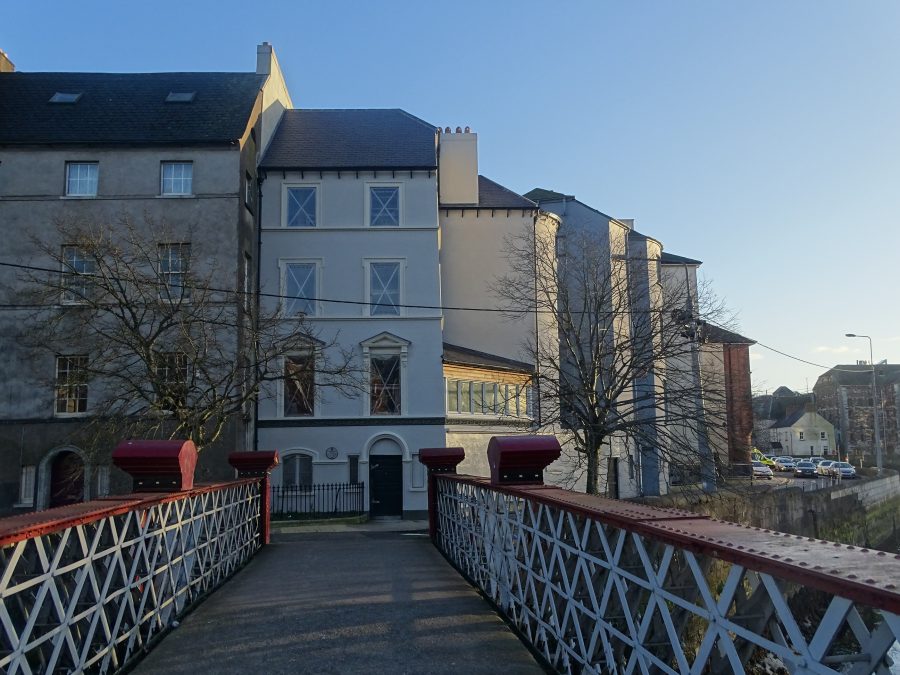
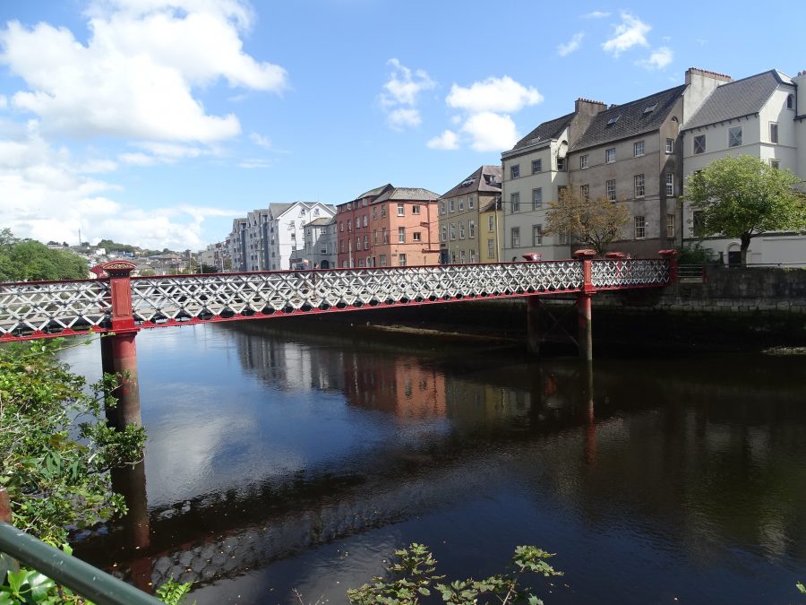
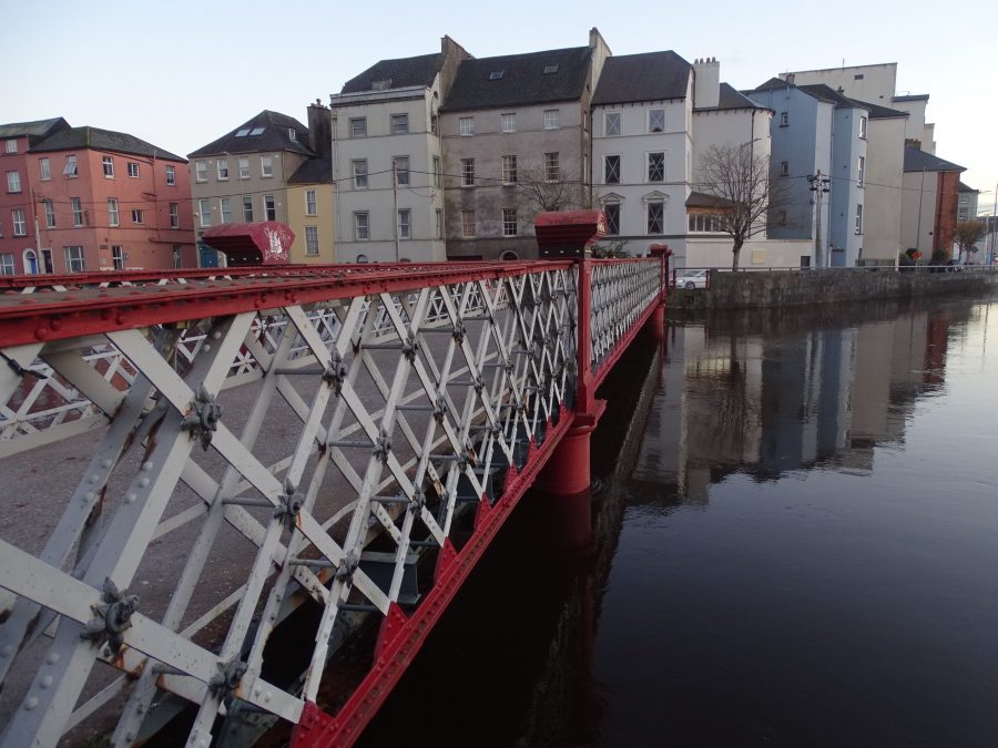
St Vincent’s Bridge:
In 1875, a steel lattice (Grid) Girder bridge was built on the site and this still stands there today. The bridge is supported by two pairs of steel pillars on each side, each filled with concrete while the pedestrian’s roadway is concrete on top of a steel base. In more recent years, St. Vincent’s Bridge has been revamped through painting and its general structure restrengthened.